Kardamýli geodata
Kardamýli (Peloponnese) is a seat of a third-order administrative division; located in Greece in Europe/Athens (GMT+3) time zone. With population of 300 people, there are 1811 cities with bigger population in this country. Compared to other cities in Greece, 90.5% of cities are located further ↑North; 66.6% of cities are located further →East and 82.6% of cities have higher elevation than Kardamýli. Note1


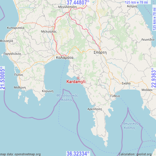
Kardamýli GPS coordinates[2]
36° 53' 16.008" North, 22° 13' 59.412" East
| Map corner | latitude | longitude |
|---|---|---|
| Upper-left | 37.44807°, | 21.53005° |
| Center: | 36.88778°, | 22.23317° |
| Lower-right: | 36.32334°, | 22.9363° |
| Map W x H: | 125.1×125.1 km | = 77.7×77.7mi |
| max Lat: | 41.72048° ⇑90.5% North |
| Kardamýli: | 36.88778° |
| min Lat: | ⇓9.5% South 34.8346° |
| min Long | Kardamýli | max Long |
| 19.40494° | 22.23317° | 29.59361° |
| W 33.4%⇐ | ⇒66.6% E |
Elevation
Elevation of Kardamýli is 15 m = 49 ft, and this is 153.9 m = 505 ft below average elevation for this country.
| Max E: |
1439 m = 4721 ft | 82.6% |
| Avg. | 168.9 m = 554 ft | |
| Kardamýli | 15 m = 49 ft | |
Min E: |
0 m = 0 ft | 17.4% |
See also: Greece elevation on elevation.city.
Geographical zone
Kardamýli is located in North temperate zone (between Tropic of Cancer and the Arctic Circle). Distance of this Northern Tropic circle is 1495.6 km =929.3 mi to South.| Distance of | km | miles | from Kardamýli |
|---|---|---|---|
| North Pole | 5905.5 | 3669.5 | to North |
| Arctic Circle | 3299.6 | 2050.3 | to North |
| Tropic Cancer | 1495.6 | 929.3 | to South |
| Equator | 4101.5 | 2548.6 | to South |


Nearby cities:
15 places around Kardamýli: (largest is in red/bold)
• Asprókhoma
22.7 km =14.1 mi,  321°
321°
• Kalamata
19.9 km =12.4 mi,  327°
327°
• Koróni
26.6 km =16.5 mi,  247°
247°
• Krokeés
27.9 km =17.3 mi,  91°
91°
• Laíika
22.9 km =14.2 mi, 327°
• Magoúla
26.3 km =16.3 mi,  35°
35°
• Messíni
27 km =16.8 mi,  312°
312°
• Mikrománi
27.6 km =17.1 mi, 319°
• Mikrá Mantíneia
13 km =8.1 mi, 327°
• Paralía Vérgas
14.9 km =9.3 mi, 332°
• Sperchógeia
25.7 km =16 mi, 323°
• Spárti
27.1 km =16.8 mi, 40°
• Stoúpa
5.4 km =3.4 mi,  154°
154°
• Thouría
27.2 km =16.9 mi, 323°
• Xirokámbion
21 km =13 mi,  67°
67°
Sources, notices
• [Note1] Compared only with cities in Greece existing in our database
• [Src1] Map data: © OpenStreetMap contributors (CC-BY-SA)
• [Src2] Other city data from geonames.org with taken over terms of usage.
• [Src3] Geographical zone / Annual Mean Temperature by Robert A. Rohde @ Wikipedia
