Áris geodata
Áris (Peloponnese) is a populated place; located in Greece in Europe/Athens (GMT+3) time zone. With population of 1,036 people, there are 976 cities with bigger population in this country. Compared to other cities in Greece, 88.9% of cities are located further ↑North; 72.2% of cities are located further →East and 75.5% of cities have higher elevation than Áris. Note1


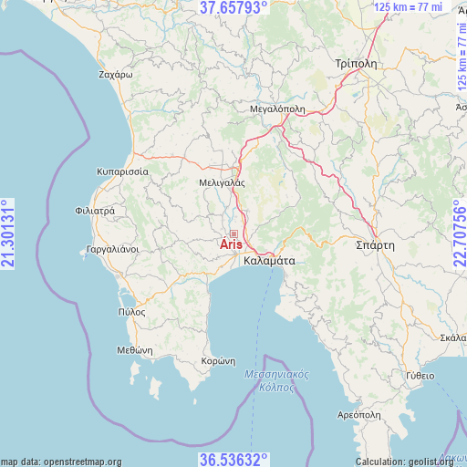
Áris GPS coordinates[2]
37° 5' 57.12" North, 22° 0' 15.948" East
| Map corner | latitude | longitude |
|---|---|---|
| Upper-left | 37.65793°, | 21.30131° |
| Center: | 37.0992°, | 22.00443° |
| Lower-right: | 36.53632°, | 22.70756° |
| Map W x H: | 124.7×124.7 km | = 77.5×77.5mi |
| max Lat: | 41.72048° ⇑88.9% North |
| Áris: | 37.0992° |
| min Lat: | ⇓11.1% South 34.8346° |
| min Long | Áris | max Long |
| 19.40494° | 22.00443° | 29.59361° |
| W 27.8%⇐ | ⇒72.2% E |
Elevation
Elevation of Áris is 23 m = 75 ft, and this is 145.9 m = 479 ft below average elevation for this country.
| Max E: |
1439 m = 4721 ft | 75.5% |
| Avg. | 168.9 m = 554 ft | |
| Áris | 23 m = 75 ft | |
Min E: |
0 m = 0 ft | 24.5% |
See also: Greece elevation on elevation.city.
Geographical zone
Áris is located in North temperate zone (between Tropic of Cancer and the Arctic Circle). Distance of this Northern Tropic circle is 1519.1 km =943.9 mi to South.| Distance of | km | miles | from Áris |
|---|---|---|---|
| North Pole | 5882 | 3654.9 | to North |
| Arctic Circle | 3276.1 | 2035.7 | to North |
| Tropic Cancer | 1519.1 | 943.9 | to South |
| Equator | 4125 | 2563.2 | to South |


Nearby cities:
15 places around Áris: (largest is in red/bold)
• Arfará
7.3 km =4.5 mi,  29°
29°
• Asprókhoma
8.5 km =5.3 mi,  132°
132°
• Chóra
26.1 km =16.2 mi,  258°
258°
• Kalamata
11.7 km =7.3 mi,  124°
124°
• Kopanáki
26.8 km =16.7 mi,  322°
322°
• Laíika
9.1 km =5.7 mi, 117°
• Meligalás
13.5 km =8.4 mi,  345°
345°
• Messíni
5.4 km =3.4 mi,  176°
176°
• Mikrománi
3.5 km =2.2 mi, 134°
• Mikrá Mantíneia
18.2 km =11.3 mi, 133°
• Paralía Vérgas
17 km =10.6 mi, 127°
• Sperchógeia
5.9 km =3.7 mi, 118°
• Thouría
4.3 km =2.7 mi,  113°
113°
• Valýra
7.6 km =4.7 mi,  344°
344°
• Vlachópoulo
20.3 km =12.6 mi,  248°
248°
Sources, notices
• [Note1] Compared only with cities in Greece existing in our database
• [Src1] Map data: © OpenStreetMap contributors (CC-BY-SA)
• [Src2] Other city data from geonames.org with taken over terms of usage.
• [Src3] Geographical zone / Annual Mean Temperature by Robert A. Rohde @ Wikipedia
