Vlachópoulo geodata
Vlachópoulo (Peloponnese) is a populated place; located in Greece in Europe/Athens (GMT+3) time zone. With population of 1,446 people, there are 692 cities with bigger population in this country. Compared to other cities in Greece, 89.9% of cities are located further ↑North; 76.6% of cities are located further →East and 86.7% of cities have lower elevation than Vlachópoulo. Note1
Administrative division(s):
- Level 1: Peloponnese
- Level 2: Nomós Messinías
- Level 3: Dimos Pylos-Nestoras


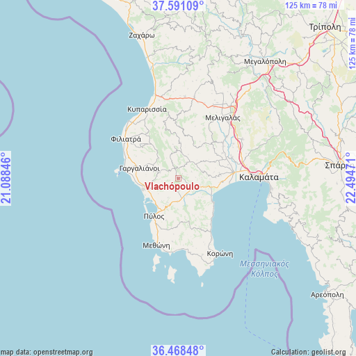
Vlachópoulo GPS coordinates[2]
37° 1' 54.696" North, 21° 47' 29.688" East
| Map corner | latitude | longitude |
|---|---|---|
| Upper-left | 37.59109°, | 21.08846° |
| Center: | 37.03186°, | 21.79158° |
| Lower-right: | 36.46848°, | 22.49471° |
| Map W x H: | 124.8×124.8 km | = 77.5×77.5mi |
| max Lat: | 41.72048° ⇑89.9% North |
| Vlachópoulo: | 37.03186° |
| min Lat: | ⇓10.1% South 34.8346° |
| min Long | Vlachópoulo | max Long |
| 19.40494° | 21.79158° | 29.59361° |
| W 23.4%⇐ | ⇒76.6% E |
Elevation
Elevation of Vlachópoulo is 430 m = 1411 ft, and this is 261.1 m = 857 ft above average elevation for this country.
| Max E: |
1439 m = 4721 ft | 13.3% |
| Vlachópoulo | 430 m 1411 ft | |
| Avg. | 168.9 m = 554 ft | |
Min E: |
0 m = 0 ft | 86.7% |
See also: Greece elevation on elevation.city.
Geographical zone
Vlachópoulo is located in North temperate zone (between Tropic of Cancer and the Arctic Circle). Distance of this Northern Tropic circle is 1511.6 km =939.3 mi to South.| Distance of | km | miles | from Vlachópoulo |
|---|---|---|---|
| North Pole | 5889.5 | 3659.6 | to North |
| Arctic Circle | 3283.6 | 2040.3 | to North |
| Tropic Cancer | 1511.6 | 939.3 | to South |
| Equator | 4117.6 | 2558.6 | to South |


Nearby cities:
15 places around Vlachópoulo: (largest is in red/bold)
• Asprókhoma
25.2 km =15.7 mi,  85°
85°
• Chóra
7 km =4.3 mi,  287°
287°
• Filiatrá
22.9 km =14.2 mi,  307°
307°
• Gargaliánoi
14.1 km =8.8 mi, 285°
• Longá
20.8 km =12.9 mi,  150°
150°
• Marathópolis
19.1 km =11.9 mi,  278°
278°
• Meligalás
25.8 km =16 mi,  37°
37°
• Messíni
19.3 km =12 mi,  83°
83°
• Methóni
24.8 km =15.4 mi,  198°
198°
• Mikrománi
21.9 km =13.6 mi, 76°
• Pýlos
15.7 km =9.8 mi,  212°
212°
• Sperchógeia
24.5 km =15.2 mi, 78°
• Thouría
23.5 km =14.6 mi, 75°
• Valýra
22.5 km =14 mi,  48°
48°
• Áris
20.3 km =12.6 mi,  68°
68°
Sources, notices
• [Note1] Compared only with cities in Greece existing in our database
• [Src1] Map data: © OpenStreetMap contributors (CC-BY-SA)
• [Src2] Other city data from geonames.org with taken over terms of usage.
• [Src3] Geographical zone / Annual Mean Temperature by Robert A. Rohde @ Wikipedia
