Pýrgos geodata
Pýrgos (West Greece) is a seat of a second-order administrative division; located in Greece in Europe/Athens (GMT+3) time zone. With population of 22,399 people, there are 85 cities with bigger population in this country. Compared to other cities in Greece, 83.3% of cities are located further ↑North; 83.9% of cities are located further →East and 74.1% of cities have higher elevation than Pýrgos. Note1


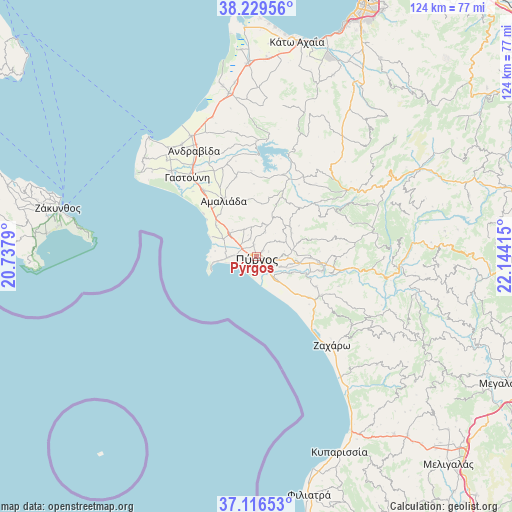
Pýrgos GPS coordinates[2]
37° 40' 30.468" North, 21° 26' 27.672" East
| Map corner | latitude | longitude |
|---|---|---|
| Upper-left | 38.22956°, | 20.7379° |
| Center: | 37.67513°, | 21.44102° |
| Lower-right: | 37.11653°, | 22.14415° |
| Map W x H: | 123.8×123.8 km | = 76.9×76.9mi |
| max Lat: | 41.72048° ⇑83.3% North |
| Pýrgos: | 37.67513° |
| min Lat: | ⇓16.7% South 34.8346° |
| min Long | Pýrgos | max Long |
| 19.40494° | 21.44102° | 29.59361° |
| W 16.1%⇐ | ⇒83.9% E |
Elevation
Elevation of Pýrgos is 25 m = 82 ft, and this is 143.9 m = 472 ft below average elevation for this country.
| Max E: |
1439 m = 4721 ft | 74.1% |
| Avg. | 168.9 m = 554 ft | |
| Pýrgos | 25 m = 82 ft | |
Min E: |
0 m = 0 ft | 25.9% |
See also: Greece elevation on elevation.city.
Geographical zone
Pýrgos is located in North temperate zone (between Tropic of Cancer and the Arctic Circle). Distance of this Northern Tropic circle is 1583.2 km =983.8 mi to South.| Distance of | km | miles | from Pýrgos |
|---|---|---|---|
| North Pole | 5818 | 3615.1 | to North |
| Arctic Circle | 3212.1 | 1995.9 | to North |
| Tropic Cancer | 1583.2 | 983.8 | to South |
| Equator | 4189.1 | 2603 | to South |


Nearby cities:
15 places around Pýrgos: (largest is in red/bold)
• Alfeioúsa
9.3 km =5.8 mi,  114°
114°
• Amaliáda
15.8 km =9.8 mi,  329°
329°
• Archaía Olympía
16.7 km =10.4 mi,  100°
100°
• Chávari
19.9 km =12.4 mi,  345°
345°
• Epitálio
7.2 km =4.5 mi,  138°
138°
• Goúmero
18.4 km =11.4 mi,  58°
58°
• Kardamás
13.6 km =8.5 mi,  318°
318°
• Karátoula
10.7 km =6.6 mi,  51°
51°
• Katákolo
11.1 km =6.9 mi,  258°
258°
• Kréstena
18.3 km =11.4 mi,  120°
120°
• Makrísia
16.2 km =10.1 mi, 116°
• Myrtiá
9.2 km =5.7 mi,  298°
298°
• Pelópi
13.4 km =8.3 mi,  90°
90°
• Plátanos
15 km =9.3 mi, 93°
• Varvásaina
5.1 km =3.2 mi, 95°
Sources, notices
• [Note1] Compared only with cities in Greece existing in our database
• [Src1] Map data: © OpenStreetMap contributors (CC-BY-SA)
• [Src2] Other city data from geonames.org with taken over terms of usage.
• [Src3] Geographical zone / Annual Mean Temperature by Robert A. Rohde @ Wikipedia
