Plátanos geodata
Plátanos (West Greece) is a populated place; located in Greece in Europe/Athens (GMT+3) time zone. With population of 1,764 people, there are 581 cities with bigger population in this country. Compared to other cities in Greece, 83.5% of cities are located further ↑North; 81.1% of cities are located further →East and 57.4% of cities have higher elevation than Plátanos. Note1


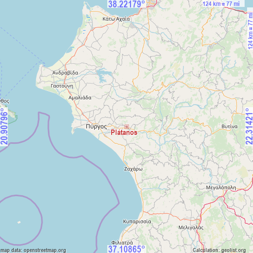
Plátanos GPS coordinates[2]
37° 40' 2.316" North, 21° 36' 39.888" East
| Map corner | latitude | longitude |
|---|---|---|
| Upper-left | 38.22179°, | 20.90796° |
| Center: | 37.66731°, | 21.61108° |
| Lower-right: | 37.10865°, | 22.31421° |
| Map W x H: | 123.8×123.8 km | = 76.9×76.9mi |
| max Lat: | 41.72048° ⇑83.5% North |
| Plátanos: | 37.66731° |
| min Lat: | ⇓16.5% South 34.8346° |
| min Long | Plátanos | max Long |
| 19.40494° | 21.61108° | 29.59361° |
| W 18.9%⇐ | ⇒81.1% E |
Elevation
Elevation of Plátanos is 58 m = 190 ft, and this is 110.9 m = 364 ft below average elevation for this country.
| Max E: |
1439 m = 4721 ft | 57.4% |
| Avg. | 168.9 m = 554 ft | |
| Plátanos | 58 m = 190 ft | |
Min E: |
0 m = 0 ft | 42.6% |
See also: Greece elevation on elevation.city.
Geographical zone
Plátanos is located in North temperate zone (between Tropic of Cancer and the Arctic Circle). Distance of this Northern Tropic circle is 1582.3 km =983.2 mi to South.| Distance of | km | miles | from Plátanos |
|---|---|---|---|
| North Pole | 5818.8 | 3615.6 | to North |
| Arctic Circle | 3213 | 1996.5 | to North |
| Tropic Cancer | 1582.3 | 983.2 | to South |
| Equator | 4188.2 | 2602.4 | to South |


Nearby cities:
15 places around Plátanos: (largest is in red/bold)
• Alfeioúsa
7.1 km =4.4 mi,  245°
245°
• Archaía Olympía
2.6 km =1.6 mi,  146°
146°
• Epitálio
11.1 km =6.9 mi, 246°
• Goúmero
10.6 km =6.6 mi,  3°
3°
• Kallithéa
22.4 km =13.9 mi,  124°
124°
• Karátoula
10.1 km =6.3 mi,  318°
318°
• Kréstena
8.4 km =5.2 mi,  174°
174°
• Lálas
10.8 km =6.7 mi,  64°
64°
• Makrísia
6.4 km =4 mi,  184°
184°
• Myrtiá
23.6 km =14.7 mi,  282°
282°
• Pelópi
1.7 km =1.1 mi,  297°
297°
• Pýrgos
15 km =9.3 mi,  273°
273°
• Varvásaina
9.9 km =6.2 mi, 272°
• Vrína
11.2 km =7 mi, 167°
• Zacháro
20.7 km =12.9 mi, 170°
Sources, notices
• [Note1] Compared only with cities in Greece existing in our database
• [Src1] Map data: © OpenStreetMap contributors (CC-BY-SA)
• [Src2] Other city data from geonames.org with taken over terms of usage.
• [Src3] Geographical zone / Annual Mean Temperature by Robert A. Rohde @ Wikipedia
