Goúmero geodata
Goúmero (West Greece) is a populated place; located in Greece in Europe/Athens (GMT+3) time zone. With population of 1,072 people, there are 942 cities with bigger population in this country. Compared to other cities in Greece, 81.1% of cities are located further ↑North; 80.8% of cities are located further →East and 89.4% of cities have lower elevation than Goúmero. Note1


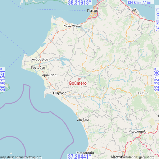
Goúmero GPS coordinates[2]
37° 45' 44.496" North, 21° 37' 6.708" East
| Map corner | latitude | longitude |
|---|---|---|
| Upper-left | 38.31613°, | 20.91541° |
| Center: | 37.76236°, | 21.61853° |
| Lower-right: | 37.20441°, | 22.32166° |
| Map W x H: | 123.6×123.6 km | = 76.8×76.8mi |
| max Lat: | 41.72048° ⇑81.1% North |
| Goúmero: | 37.76236° |
| min Lat: | ⇓18.9% South 34.8346° |
| min Long | Goúmero | max Long |
| 19.40494° | 21.61853° | 29.59361° |
| W 19.2%⇐ | ⇒80.8% E |
Elevation
Elevation of Goúmero is 500 m = 1640 ft, and this is 331.1 m = 1086 ft above average elevation for this country.
| Max E: |
1439 m = 4721 ft | 10.6% |
| Goúmero | 500 m 1640 ft | |
| Avg. | 168.9 m = 554 ft | |
Min E: |
0 m = 0 ft | 89.4% |
See also: Greece elevation on elevation.city.
Geographical zone
Goúmero is located in North temperate zone (between Tropic of Cancer and the Arctic Circle). Distance of this Northern Tropic circle is 1592.9 km =989.8 mi to South.| Distance of | km | miles | from Goúmero |
|---|---|---|---|
| North Pole | 5808.3 | 3609.1 | to North |
| Arctic Circle | 3202.4 | 1989.9 | to North |
| Tropic Cancer | 1592.9 | 989.8 | to South |
| Equator | 4198.8 | 2609 | to South |


Nearby cities:
15 places around Goúmero: (largest is in red/bold)
• Alfeioúsa
15.3 km =9.5 mi,  207°
207°
• Amaliáda
23.9 km =14.9 mi,  279°
279°
• Archaía Olympía
12.8 km =8 mi,  176°
176°
• Chávari
22.7 km =14.1 mi,  294°
294°
• Epitálio
18.6 km =11.6 mi,  215°
215°
• Karátoula
7.9 km =4.9 mi,  247°
247°
• Kréstena
19 km =11.8 mi, 179°
• Lálas
10.8 km =6.7 mi,  123°
123°
• Makrísia
17 km =10.6 mi, 183°
• Pelópi
10 km =6.2 mi,  192°
192°
• Plátanos
10.6 km =6.6 mi, 183°
• Pýrgos
18.4 km =11.4 mi,  238°
238°
• Synoikismós Chavaríou
22.8 km =14.2 mi,  297°
297°
• Varvásaina
14.6 km =9.1 mi,  226°
226°
• Vrína
21.6 km =13.4 mi, 175°
Sources, notices
• [Note1] Compared only with cities in Greece existing in our database
• [Src1] Map data: © OpenStreetMap contributors (CC-BY-SA)
• [Src2] Other city data from geonames.org with taken over terms of usage.
• [Src3] Geographical zone / Annual Mean Temperature by Robert A. Rohde @ Wikipedia
