Anávra geodata
Anávra (Thessaly) is a populated place; located in Greece in Europe/Athens (GMT+3) time zone. With population of 1,145 people, there are 873 cities with bigger population in this country. Compared to other cities in Greece, 50.4% of cities are located further ↑North; 69.9% of cities are located further →East and 73.9% of cities have lower elevation than Anávra. Note1


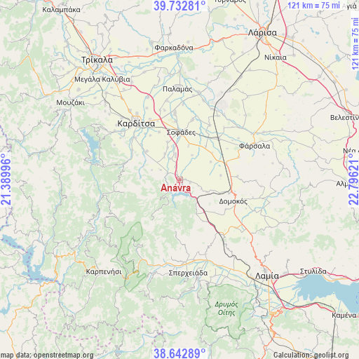
Anávra GPS coordinates[2]
39° 11' 23.856" North, 22° 5' 35.088" East
| Map corner | latitude | longitude |
|---|---|---|
| Upper-left | 39.73281°, | 21.38996° |
| Center: | 39.18996°, | 22.09308° |
| Lower-right: | 38.64289°, | 22.79621° |
| Map W x H: | 121.2×121.2 km | = 75.3×75.3mi |
| max Lat: | 41.72048° ⇑50.4% North |
| Anávra: | 39.18996° |
| min Lat: | ⇓49.6% South 34.8346° |
| min Long | Anávra | max Long |
| 19.40494° | 22.09308° | 29.59361° |
| W 30.1%⇐ | ⇒69.9% E |
Elevation
Elevation of Anávra is 199 m = 653 ft, and this is 30.1 m = 99 ft above average elevation for this country.
| Max E: |
1439 m = 4721 ft | 26.1% |
| Anávra | 199 m 653 ft | |
| Avg. | 168.9 m = 554 ft | |
Min E: |
0 m = 0 ft | 73.9% |
See also: Greece elevation on elevation.city.
Geographical zone
Anávra is located in North temperate zone (between Tropic of Cancer and the Arctic Circle). Distance of this Northern Tropic circle is 1751.6 km =1088.4 mi to South.| Distance of | km | miles | from Anávra |
|---|---|---|---|
| North Pole | 5649.5 | 3510.4 | to North |
| Arctic Circle | 3043.7 | 1891.3 | to North |
| Tropic Cancer | 1751.6 | 1088.4 | to South |
| Equator | 4357.5 | 2707.6 | to South |


Nearby cities:
15 places around Anávra: (largest is in red/bold)
• Domokós
19.2 km =11.9 mi,  111°
111°
• Ekkára
9.8 km =6.1 mi, 114°
• Kallifóni
14.9 km =9.3 mi,  310°
310°
• Kallíthiro
19.1 km =11.9 mi,  301°
301°
• Karpochóri
17.7 km =11 mi,  336°
336°
• Mavrika
21.4 km =13.3 mi,  322°
322°
• Néon Monastírion
16.6 km =10.3 mi,  70°
70°
• Omvriakí
18.2 km =11.3 mi,  122°
122°
• Palioúri
10.2 km =6.3 mi,  289°
289°
• Pródromos
23 km =14.3 mi,  333°
333°
• Rentína
17.2 km =10.7 mi,  214°
214°
• Roússo
21.2 km =13.2 mi, 309°
• Sofádes
16 km =9.9 mi,  2°
2°
• Stavrós
21.8 km =13.5 mi, 331°
• Zaḯmi
18 km =11.2 mi, 312°
Sources, notices
• [Note1] Compared only with cities in Greece existing in our database
• [Src1] Map data: © OpenStreetMap contributors (CC-BY-SA)
• [Src2] Other city data from geonames.org with taken over terms of usage.
• [Src3] Geographical zone / Annual Mean Temperature by Robert A. Rohde @ Wikipedia
