Palaióchora geodata
Palaióchora (Crete) is a seat of a third-order administrative division; located in Greece in Europe/Athens (GMT+3) time zone. With population of 2,372 people, there are 443 cities with bigger population in this country. Compared to other cities in Greece, 97.6% of cities are located further ↑North; 69.3% of cities are located further ←West and 95.6% of cities have higher elevation than Palaióchora. Note1


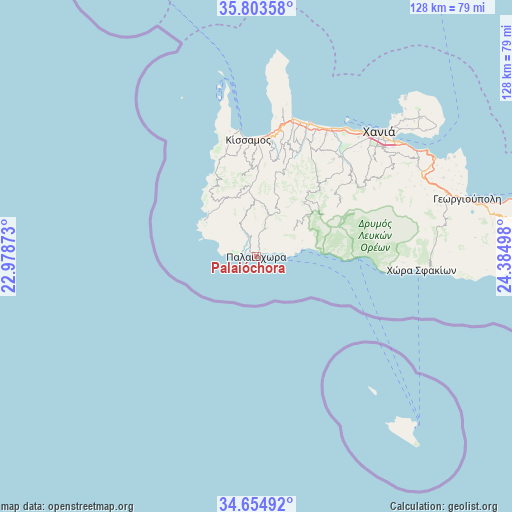
Palaióchora GPS coordinates[2]
35° 13' 52.608" North, 23° 40' 54.66" East
| Map corner | latitude | longitude |
|---|---|---|
| Upper-left | 35.80358°, | 22.97873° |
| Center: | 35.23128°, | 23.68185° |
| Lower-right: | 34.65492°, | 24.38498° |
| Map W x H: | 127.7×127.7 km | = 79.3×79.3mi |
| max Lat: | 41.72048° ⇑97.6% North |
| Palaióchora: | 35.23128° |
| min Lat: | ⇓2.4% South 34.8346° |
| min Long | Palaióchora | max Long |
| 19.40494° | 23.68185° | 29.59361° |
| W 69.3%⇐ | ⇒30.7% E |
Elevation
Elevation of Palaióchora is 5 m = 16 ft, and this is 163.9 m = 538 ft below average elevation for this country.
| Max E: |
1439 m = 4721 ft | 95.6% |
| Avg. | 168.9 m = 554 ft | |
| Palaióchora | 5 m = 16 ft | |
Min E: |
0 m = 0 ft | 4.4% |
See also: Greece elevation on elevation.city.
Geographical zone
Palaióchora is located in North temperate zone (between Tropic of Cancer and the Arctic Circle). Distance of this Northern Tropic circle is 1311.4 km =814.9 mi to South.| Distance of | km | miles | from Palaióchora |
|---|---|---|---|
| North Pole | 6089.7 | 3784 | to North |
| Arctic Circle | 3483.8 | 2164.7 | to North |
| Tropic Cancer | 1311.4 | 814.9 | to South |
| Equator | 3917.4 | 2434.2 | to South |


Nearby cities:
15 places around Palaióchora: (largest is in red/bold)
• Agía Marína
38.8 km =24.1 mi,  34°
34°
• Chóra Sfakíon
41.5 km =25.8 mi,  94°
94°
• Darátsos
39.9 km =24.8 mi,  41°
41°
• Galatás
39.2 km =24.4 mi, 40°
• Geráni
36.4 km =22.6 mi, 29°
• Gialós
4.4 km =2.7 mi,  281°
281°
• Kolympári
35.6 km =22.1 mi,  14°
14°
• Kíssamos
29.4 km =18.3 mi,  355°
355°
• Mourniés
41 km =25.5 mi,  47°
47°
• Nerokoúros
42.4 km =26.3 mi, 50°
• Perivólia
40 km =24.9 mi, 45°
• Plátanos
27.8 km =17.3 mi,  344°
344°
• Stalós
38.7 km =24 mi, 37°
• Tavronítis
35.5 km =22.1 mi,  20°
20°
• Tsikalariá
44 km =27.3 mi, 51°
Sources, notices
• [Note1] Compared only with cities in Greece existing in our database
• [Src1] Map data: © OpenStreetMap contributors (CC-BY-SA)
• [Src2] Other city data from geonames.org with taken over terms of usage.
• [Src3] Geographical zone / Annual Mean Temperature by Robert A. Rohde @ Wikipedia
