Kopanáki geodata
Kopanáki (Peloponnese) is a populated place; located in Greece in Europe/Athens (GMT+3) time zone. With population of 1,500 people, there are 660 cities with bigger population in this country. Compared to other cities in Greece, 87.8% of cities are located further ↑North; 76% of cities are located further →East and 72.1% of cities have lower elevation than Kopanáki. Note1


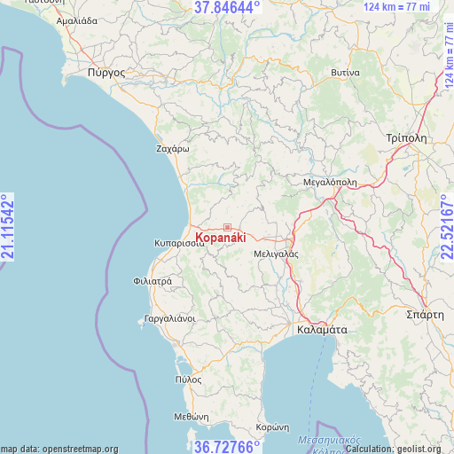
Kopanáki GPS coordinates[2]
37° 17' 20.868" North, 21° 49' 6.744" East
| Map corner | latitude | longitude |
|---|---|---|
| Upper-left | 37.84644°, | 21.11542° |
| Center: | 37.28913°, | 21.81854° |
| Lower-right: | 36.72766°, | 22.52167° |
| Map W x H: | 124.4×124.4 km | = 77.3×77.3mi |
| max Lat: | 41.72048° ⇑87.8% North |
| Kopanáki: | 37.28913° |
| min Lat: | ⇓12.2% South 34.8346° |
| min Long | Kopanáki | max Long |
| 19.40494° | 21.81854° | 29.59361° |
| W 24%⇐ | ⇒76% E |
Elevation
Elevation of Kopanáki is 182 m = 597 ft, and this is 13.1 m = 43 ft above average elevation for this country.
| Max E: |
1439 m = 4721 ft | 27.9% |
| Kopanáki | 182 m 597 ft | |
| Avg. | 168.9 m = 554 ft | |
Min E: |
0 m = 0 ft | 72.1% |
See also: Greece elevation on elevation.city.
Geographical zone
Kopanáki is located in North temperate zone (between Tropic of Cancer and the Arctic Circle). Distance of this Northern Tropic circle is 1540.2 km =957 mi to South.| Distance of | km | miles | from Kopanáki |
|---|---|---|---|
| North Pole | 5860.9 | 3641.8 | to North |
| Arctic Circle | 3255 | 2022.6 | to North |
| Tropic Cancer | 1540.2 | 957 | to South |
| Equator | 4146.2 | 2576.3 | to South |


Nearby cities:
15 places around Kopanáki: (largest is in red/bold)
• Andrítsaina
23 km =14.3 mi,  19°
19°
• Arfará
24.9 km =15.5 mi,  126°
126°
• Chóra
28 km =17.4 mi,  198°
198°
• Filiatrá
25.4 km =15.8 mi,  234°
234°
• Gargaliánoi
29.6 km =18.4 mi,  212°
212°
• Kallithéa
29.2 km =18.1 mi,  0°
0°
• Kyparissía
13.5 km =8.4 mi,  251°
251°
• Megalópoli
31.2 km =19.4 mi,  66°
66°
• Meligalás
15.4 km =9.6 mi,  121°
121°
• Mikrománi
30.2 km =18.8 mi,  141°
141°
• Thouría
30.6 km =19 mi, 138°
• Valýra
19.9 km =12.4 mi, 133°
• Vlachópoulo
28.7 km =17.8 mi,  184°
184°
• Zacháro
26.2 km =16.3 mi,  325°
325°
• Áris
26.8 km =16.7 mi, 142°
Sources, notices
• [Note1] Compared only with cities in Greece existing in our database
• [Src1] Map data: © OpenStreetMap contributors (CC-BY-SA)
• [Src2] Other city data from geonames.org with taken over terms of usage.
• [Src3] Geographical zone / Annual Mean Temperature by Robert A. Rohde @ Wikipedia
