Dímitra geodata
Dímitra (West Macedonia) is a populated place; located in Greece in Europe/Athens (GMT+3) time zone. With population of 548 people, there are 1700 cities with bigger population in this country. Compared to other cities in Greece, 66.1% of cities are located further ↓South; 79.5% of cities are located further →East and 87.9% of cities have lower elevation than Dímitra. Note1


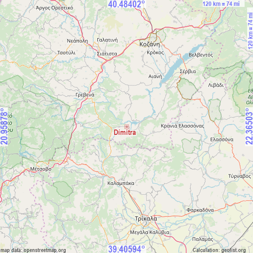
Dímitra GPS coordinates[2]
39° 56' 49.56" North, 21° 39' 42.84" East
| Map corner | latitude | longitude |
|---|---|---|
| Upper-left | 40.48402°, | 20.95878° |
| Center: | 39.9471°, | 21.6619° |
| Lower-right: | 39.40594°, | 22.36503° |
| Map W x H: | 119.9×119.9 km | = 74.5×74.5mi |
| max Lat: | 41.72048° ⇑33.9% North |
| Dímitra: | 39.9471° |
| min Lat: | ⇓66.1% South 34.8346° |
| min Long | Dímitra | max Long |
| 19.40494° | 21.6619° | 29.59361° |
| W 20.5%⇐ | ⇒79.5% E |
Elevation
Elevation of Dímitra is 453 m = 1486 ft, and this is 284.1 m = 932 ft above average elevation for this country.
| Max E: |
1439 m = 4721 ft | 12.1% |
| Dímitra | 453 m 1486 ft | |
| Avg. | 168.9 m = 554 ft | |
Min E: |
0 m = 0 ft | 87.9% |
See also: Greece elevation on elevation.city.
Geographical zone
Dímitra is located in North temperate zone (between Tropic of Cancer and the Arctic Circle). Distance of this Northern Tropic circle is 1835.8 km =1140.7 mi to South.| Distance of | km | miles | from Dímitra |
|---|---|---|---|
| North Pole | 5565.4 | 3458.2 | to North |
| Arctic Circle | 2959.5 | 1838.9 | to North |
| Tropic Cancer | 1835.8 | 1140.7 | to South |
| Equator | 4441.7 | 2759.9 | to South |


Nearby cities:
15 places around Dímitra: (largest is in red/bold)
• Agiófyllo
12.6 km =7.8 mi,  222°
222°
• Agnantiá
18.9 km =11.7 mi,  242°
242°
• Aianí
27.6 km =17.1 mi,  29°
29°
• Asprokklisiá
10.7 km =6.6 mi,  179°
179°
• Deskáti
12.9 km =8 mi,  101°
101°
• Eláti
14.2 km =8.8 mi,  75°
75°
• Grevená
25.1 km =15.6 mi,  307°
307°
• Kalampáka
27.1 km =16.8 mi,  186°
186°
• Karperó
3.7 km =2.3 mi,  270°
270°
• Kastráki
25.9 km =16.1 mi, 188°
• Kraniá Elassónas
26.3 km =16.3 mi,  89°
89°
• Livaderó
25.8 km =16 mi,  67°
67°
• Loutró
23.3 km =14.5 mi, 84°
• Oxýneia
19.9 km =12.4 mi,  227°
227°
• Ávra
26.3 km =16.3 mi,  174°
174°
Sources, notices
• [Note1] Compared only with cities in Greece existing in our database
• [Src1] Map data: © OpenStreetMap contributors (CC-BY-SA)
• [Src2] Other city data from geonames.org with taken over terms of usage.
• [Src3] Geographical zone / Annual Mean Temperature by Robert A. Rohde @ Wikipedia
