Alíartos geodata
Alíartos (Central Greece) is a seat of a third-order administrative division; located in Greece in Europe/Athens (GMT+3) time zone. With population of 4,275 people, there are 268 cities with bigger population in this country. Compared to other cities in Greece, 64.4% of cities are located further ↑North; 57% of cities are located further ←West and 72.3% of cities have lower elevation than Alíartos. Note1


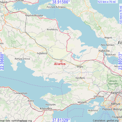
Alíartos GPS coordinates[2]
38° 22' 0.012" North, 23° 6' 0" East
| Map corner | latitude | longitude |
|---|---|---|
| Upper-left | 38.91586°, | 22.39688° |
| Center: | 38.36667°, | 23.1° |
| Lower-right: | 37.81329°, | 23.80313° |
| Map W x H: | 122.6×122.6 km | = 76.2×76.2mi |
| max Lat: | 41.72048° ⇑64.4% North |
| Alíartos: | 38.36667° |
| min Lat: | ⇓35.6% South 34.8346° |
| min Long | Alíartos | max Long |
| 19.40494° | 23.1° | 29.59361° |
| W 57%⇐ | ⇒43% E |
Elevation
Elevation of Alíartos is 183 m = 600 ft, and this is 14.1 m = 46 ft above average elevation for this country.
| Max E: |
1439 m = 4721 ft | 27.7% |
| Alíartos | 183 m 600 ft | |
| Avg. | 168.9 m = 554 ft | |
Min E: |
0 m = 0 ft | 72.3% |
See also: Greece elevation on elevation.city.
Geographical zone
Alíartos is located in North temperate zone (between Tropic of Cancer and the Arctic Circle). Distance of this Northern Tropic circle is 1660.1 km =1031.5 mi to South.| Distance of | km | miles | from Alíartos |
|---|---|---|---|
| North Pole | 5741.1 | 3567.4 | to North |
| Arctic Circle | 3135.2 | 1948.1 | to North |
| Tropic Cancer | 1660.1 | 1031.5 | to South |
| Equator | 4266 | 2650.8 | to South |


Nearby cities:
15 places around Alíartos: (largest is in red/bold)
• Agía Triáda
16.7 km =10.4 mi,  265°
265°
• Akraifnía
14.5 km =9 mi,  46°
46°
• Domvraína
16.3 km =10.1 mi,  219°
219°
• Erythrés
25.5 km =15.8 mi,  130°
130°
• Kaparéllion
17.5 km =10.9 mi,  145°
145°
• Kástron
15.1 km =9.4 mi,  20°
20°
• Kókkinon
17.1 km =10.6 mi, 45°
• Livadeiá
20.9 km =13 mi,  291°
291°
• Martínon
24.5 km =15.2 mi, 23°
• Orchomenós
17.5 km =10.9 mi,  323°
323°
• Plataiés
22.4 km =13.9 mi,  139°
139°
• Thespiés
8.3 km =5.2 mi, 148°
• Thívai
19.6 km =12.2 mi,  103°
103°
• Vágia
8.7 km =5.4 mi, 128°
• Ágios Geórgios
15 km =9.3 mi,  281°
281°
Sources, notices
• [Note1] Compared only with cities in Greece existing in our database
• [Src1] Map data: © OpenStreetMap contributors (CC-BY-SA)
• [Src2] Other city data from geonames.org with taken over terms of usage.
• [Src3] Geographical zone / Annual Mean Temperature by Robert A. Rohde @ Wikipedia
