Domvraína geodata
Domvraína (Central Greece) is a populated place; located in Greece in Europe/Athens (GMT+3) time zone. With population of 1,138 people, there are 878 cities with bigger population in this country. Compared to other cities in Greece, 66.8% of cities are located further ↑North; 54.3% of cities are located further ←West and 68.9% of cities have lower elevation than Domvraína. Note1


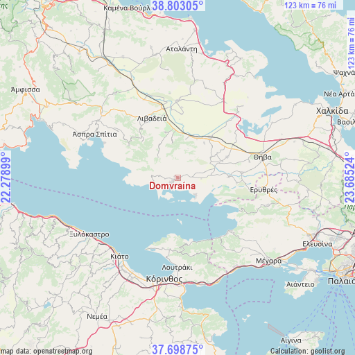
Domvraína GPS coordinates[2]
38° 15' 10.8" North, 22° 58' 55.596" East
| Map corner | latitude | longitude |
|---|---|---|
| Upper-left | 38.80305°, | 22.27899° |
| Center: | 38.253°, | 22.98211° |
| Lower-right: | 37.69875°, | 23.68524° |
| Map W x H: | 122.8×122.8 km | = 76.3×76.3mi |
| max Lat: | 41.72048° ⇑66.8% North |
| Domvraína: | 38.253° |
| min Lat: | ⇓33.2% South 34.8346° |
| min Long | Domvraína | max Long |
| 19.40494° | 22.98211° | 29.59361° |
| W 54.3%⇐ | ⇒45.7% E |
Elevation
Elevation of Domvraína is 157 m = 515 ft, and this is 11.9 m = 39 ft below average elevation for this country.
| Max E: |
1439 m = 4721 ft | 31.1% |
| Avg. | 168.9 m = 554 ft | |
| Domvraína | 157 m = 515 ft | |
Min E: |
0 m = 0 ft | 68.9% |
See also: Greece elevation on elevation.city.
Geographical zone
Domvraína is located in North temperate zone (between Tropic of Cancer and the Arctic Circle). Distance of this Northern Tropic circle is 1647.4 km =1023.6 mi to South.| Distance of | km | miles | from Domvraína |
|---|---|---|---|
| North Pole | 5753.7 | 3575.2 | to North |
| Arctic Circle | 3147.8 | 1956 | to North |
| Tropic Cancer | 1647.4 | 1023.6 | to South |
| Equator | 4253.3 | 2642.9 | to South |


Nearby cities:
15 places around Domvraína: (largest is in red/bold)
• Agía Triáda
13 km =8.1 mi,  330°
330°
• Alíartos
16.3 km =10.1 mi,  39°
39°
• Chairóneia
29.5 km =18.3 mi,  335°
335°
• Erythrés
30 km =18.6 mi,  97°
97°
• Kaparéllion
20.3 km =12.6 mi, 95°
• Kyriáki
20.3 km =12.6 mi,  303°
303°
• Livadeiá
22.3 km =13.9 mi, 335°
• Orchomenós
26.7 km =16.6 mi,  359°
359°
• Perachóra
24.9 km =15.5 mi,  186°
186°
• Plataiés
25.3 km =15.7 mi, 99°
• Steíri
29.2 km =18.1 mi,  306°
306°
• Thespiés
15.7 km =9.8 mi,  69°
69°
• Thívai
30.5 km =19 mi, 74°
• Vágia
18.5 km =11.5 mi, 67°
• Ágios Geórgios
16.2 km =10.1 mi, 344°
Sources, notices
• [Note1] Compared only with cities in Greece existing in our database
• [Src1] Map data: © OpenStreetMap contributors (CC-BY-SA)
• [Src2] Other city data from geonames.org with taken over terms of usage.
• [Src3] Geographical zone / Annual Mean Temperature by Robert A. Rohde @ Wikipedia
