Kinéta geodata
Kinéta (Attica) is a populated place; located in Greece in Europe/Athens (GMT+3) time zone. With population of 1,446 people, there are 692 cities with bigger population in this country. Compared to other cities in Greece, 74.9% of cities are located further ↑North; 58.6% of cities are located further ←West and 97.4% of cities have higher elevation than Kinéta. Note1
Administrative division(s):
- Level 1: Attica
- Level 2: Nomarchía Dytikís Attikís
- Level 3: Dimos Megara


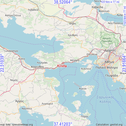
Kinéta GPS coordinates[2]
37° 58' 6.348" North, 23° 12' 48.636" East
| Map corner | latitude | longitude |
|---|---|---|
| Upper-left | 38.52064°, | 22.51039° |
| Center: | 37.96843°, | 23.21351° |
| Lower-right: | 37.41203°, | 23.91664° |
| Map W x H: | 123.3×123.3 km | = 76.6×76.6mi |
| max Lat: | 41.72048° ⇑74.9% North |
| Kinéta: | 37.96843° |
| min Lat: | ⇓25.1% South 34.8346° |
| min Long | Kinéta | max Long |
| 19.40494° | 23.21351° | 29.59361° |
| W 58.6%⇐ | ⇒41.4% E |
Elevation
Elevation of Kinéta is 4 m = 13 ft, and this is 164.9 m = 541 ft below average elevation for this country.
| Max E: |
1439 m = 4721 ft | 97.4% |
| Avg. | 168.9 m = 554 ft | |
| Kinéta | 4 m = 13 ft | |
Min E: |
0 m = 0 ft | 2.6% |
See also: Greece elevation on elevation.city.
Geographical zone
Kinéta is located in North temperate zone (between Tropic of Cancer and the Arctic Circle). Distance of this Northern Tropic circle is 1615.8 km =1004 mi to South.| Distance of | km | miles | from Kinéta |
|---|---|---|---|
| North Pole | 5785.4 | 3594.9 | to North |
| Arctic Circle | 3179.5 | 1975.6 | to North |
| Tropic Cancer | 1615.8 | 1004 | to South |
| Equator | 4221.7 | 2623.2 | to South |


Nearby cities:
15 places around Kinéta: (largest is in red/bold)
• Aiánteio
22.1 km =13.7 mi,  103°
103°
• Isthmía
19.3 km =12 mi,  251°
251°
• Kyrás Vrýsi
20.8 km =12.9 mi, 252°
• Káto Almyrí
22.8 km =14.2 mi,  234°
234°
• Kórinthos
23.2 km =14.4 mi,  262°
262°
• Loutrá Oraías Elénis
22.3 km =13.9 mi,  238°
238°
• Loutráki
20.7 km =12.9 mi,  273°
273°
• Lákka Kalogírou
15.3 km =9.5 mi,  79°
79°
• Mégara
11.7 km =7.3 mi, 75°
• Néa Péramos
18.9 km =11.7 mi, 77°
• Perachóra
24.2 km =15 mi,  286°
286°
• Páchi
13.1 km =8.1 mi,  86°
86°
• Sofikón
24 km =14.9 mi,  216°
216°
• Vlycháda
20.6 km =12.8 mi,  71°
71°
• Ágioi Theódoroi
7.7 km =4.8 mi, 233°
Sources, notices
• [Note1] Compared only with cities in Greece existing in our database
• [Src1] Map data: © OpenStreetMap contributors (CC-BY-SA)
• [Src2] Other city data from geonames.org with taken over terms of usage.
• [Src3] Geographical zone / Annual Mean Temperature by Robert A. Rohde @ Wikipedia
