Kástron geodata
Kástron (Central Greece) is a populated place; located in Greece in Europe/Athens (GMT+3) time zone. With population of 817 people, there are 1254 cities with bigger population in this country. Compared to other cities in Greece, 61.6% of cities are located further ↑North; 58.1% of cities are located further ←West and 60.5% of cities have lower elevation than Kástron. Note1
Administrative division(s):
- Level 1: Central Greece
- Level 2: Nomós Voiotías
- Level 3: Dimos Orchomenos


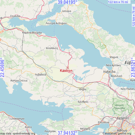
Kástron GPS coordinates[2]
38° 29' 37.464" North, 23° 9' 36.288" East
| Map corner | latitude | longitude |
|---|---|---|
| Upper-left | 39.04195°, | 22.45696° |
| Center: | 38.49374°, | 23.16008° |
| Lower-right: | 37.94132°, | 23.86321° |
| Map W x H: | 122.4×122.4 km | = 76.1×76.1mi |
| max Lat: | 41.72048° ⇑61.6% North |
| Kástron: | 38.49374° |
| min Lat: | ⇓38.4% South 34.8346° |
| min Long | Kástron | max Long |
| 19.40494° | 23.16008° | 29.59361° |
| W 58.1%⇐ | ⇒41.9% E |
Elevation
Elevation of Kástron is 119 m = 390 ft, and this is 49.9 m = 164 ft below average elevation for this country.
| Max E: |
1439 m = 4721 ft | 39.5% |
| Avg. | 168.9 m = 554 ft | |
| Kástron | 119 m = 390 ft | |
Min E: |
0 m = 0 ft | 60.5% |
See also: Greece elevation on elevation.city.
Geographical zone
Kástron is located in North temperate zone (between Tropic of Cancer and the Arctic Circle). Distance of this Northern Tropic circle is 1674.2 km =1040.3 mi to South.| Distance of | km | miles | from Kástron |
|---|---|---|---|
| North Pole | 5727 | 3558.6 | to North |
| Arctic Circle | 3121.1 | 1939.4 | to North |
| Tropic Cancer | 1674.2 | 1040.3 | to South |
| Equator | 4280.1 | 2659.5 | to South |


Nearby cities:
15 places around Kástron: (largest is in red/bold)
• Akraifnía
6.7 km =4.2 mi,  127°
127°
• Alíartos
15.1 km =9.4 mi,  200°
200°
• Atalánti
22.4 km =13.9 mi,  321°
321°
• Kókkinon
7.2 km =4.5 mi,  106°
106°
• Loukísia
25.1 km =15.6 mi,  93°
93°
• Lárimna
13.5 km =8.4 mi,  53°
53°
• Malesína
15.7 km =9.8 mi,  24°
24°
• Martínon
9.5 km =5.9 mi,  29°
29°
• Orchomenós
15.7 km =9.8 mi,  269°
269°
• Thespiés
21.2 km =13.2 mi,  182°
182°
• Thívai
23.3 km =14.5 mi,  143°
143°
• Tragána
14.4 km =8.9 mi,  347°
347°
• Vágia
19.7 km =12.2 mi, 175°
• Ágios Geórgios
22.8 km =14.2 mi,  240°
240°
• Éxarkhos
21.5 km =13.4 mi,  299°
299°
Sources, notices
• [Note1] Compared only with cities in Greece existing in our database
• [Src1] Map data: © OpenStreetMap contributors (CC-BY-SA)
• [Src2] Other city data from geonames.org with taken over terms of usage.
• [Src3] Geographical zone / Annual Mean Temperature by Robert A. Rohde @ Wikipedia
