Akraifnía geodata
Akraifnía (Central Greece) is a populated place; located in Greece in Europe/Athens (GMT+3) time zone. With population of 1,195 people, there are 832 cities with bigger population in this country. Compared to other cities in Greece, 62.3% of cities are located further ↑North; 58.9% of cities are located further ←West and 73.1% of cities have lower elevation than Akraifnía. Note1
Administrative division(s):
- Level 1: Central Greece
- Level 2: Nomós Voiotías
- Level 3: Dimos Orchomenos


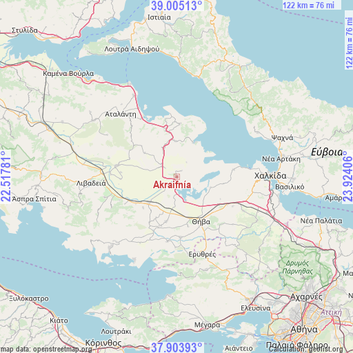
Akraifnía GPS coordinates[2]
38° 27' 23.868" North, 23° 13' 15.348" East
| Map corner | latitude | longitude |
|---|---|---|
| Upper-left | 39.00513°, | 22.51781° |
| Center: | 38.45663°, | 23.22093° |
| Lower-right: | 37.90393°, | 23.92406° |
| Map W x H: | 122.4×122.4 km | = 76.1×76.1mi |
| max Lat: | 41.72048° ⇑62.3% North |
| Akraifnía: | 38.45663° |
| min Lat: | ⇓37.7% South 34.8346° |
| min Long | Akraifnía | max Long |
| 19.40494° | 23.22093° | 29.59361° |
| W 58.9%⇐ | ⇒41.1% E |
Elevation
Elevation of Akraifnía is 191 m = 627 ft, and this is 22.1 m = 73 ft above average elevation for this country.
| Max E: |
1439 m = 4721 ft | 26.9% |
| Akraifnía | 191 m 627 ft | |
| Avg. | 168.9 m = 554 ft | |
Min E: |
0 m = 0 ft | 73.1% |
See also: Greece elevation on elevation.city.
Geographical zone
Akraifnía is located in North temperate zone (between Tropic of Cancer and the Arctic Circle). Distance of this Northern Tropic circle is 1670.1 km =1037.8 mi to South.| Distance of | km | miles | from Akraifnía |
|---|---|---|---|
| North Pole | 5731.1 | 3561.1 | to North |
| Arctic Circle | 3125.2 | 1941.9 | to North |
| Tropic Cancer | 1670.1 | 1037.8 | to South |
| Equator | 4276 | 2657 | to South |


Nearby cities:
15 places around Akraifnía: (largest is in red/bold)
• Alíartos
14.5 km =9 mi,  226°
226°
• Eleónas
22 km =13.7 mi,  118°
118°
• Kallithea - Moustafádhes
25 km =15.5 mi,  130°
130°
• Kaparéllion
24.4 km =15.2 mi,  181°
181°
• Kástron
6.7 km =4.2 mi,  307°
307°
• Kókkinon
2.6 km =1.6 mi,  37°
37°
• Loukísia
19.9 km =12.4 mi,  82°
82°
• Lárimna
13.3 km =8.3 mi,  24°
24°
• Malesína
18.4 km =11.4 mi,  3°
3°
• Martínon
12.4 km =7.7 mi,  357°
357°
• Orchomenós
21.4 km =13.3 mi,  280°
280°
• Thespiés
18.2 km =11.3 mi,  199°
199°
• Thívai
16.9 km =10.5 mi,  149°
149°
• Tragána
20 km =12.4 mi,  334°
334°
• Vágia
15.9 km =9.9 mi,  193°
193°
Sources, notices
• [Note1] Compared only with cities in Greece existing in our database
• [Src1] Map data: © OpenStreetMap contributors (CC-BY-SA)
• [Src2] Other city data from geonames.org with taken over terms of usage.
• [Src3] Geographical zone / Annual Mean Temperature by Robert A. Rohde @ Wikipedia
