Atalánti geodata
Atalánti (Central Greece) is a seat of a third-order administrative division; located in Greece in Europe/Athens (GMT+3) time zone. With population of 4,978 people, there are 237 cities with bigger population in this country. Compared to other cities in Greece, 59% of cities are located further ↑North; 54.9% of cities are located further ←West and 65.5% of cities have lower elevation than Atalánti. Note1


Atalánti GPS coordinates[2]
38° 39' 3.996" North, 22° 59' 57.012" East
| Map corner | latitude | longitude |
|---|---|---|
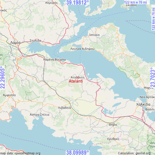
| Upper-left | 39.19812°, | 22.29605° |
| Center: | 38.65111°, | 22.99917° |
| Lower-right: | 38.09989°, | 23.7023° |
| Map W x H: | 122.1×122.1 km | = 75.9×75.9mi |
| max Lat: | 41.72048° ⇑59% North |
| Atalánti: | 38.65111° |
| min Lat: | ⇓41% South 34.8346° |
| min Long | Atalánti | max Long |
| 19.40494° | 22.99917° | 29.59361° |
| W 54.9%⇐ | ⇒45.1% E |
Elevation
Elevation of Atalánti is 142 m = 466 ft, and this is 26.9 m = 88 ft below average elevation for this country.
| Max E: |
1439 m = 4721 ft | 34.5% |
| Avg. | 168.9 m = 554 ft | |
| Atalánti | 142 m = 466 ft | |
Min E: |
0 m = 0 ft | 65.5% |
See also: Greece elevation on elevation.city.
Geographical zone
Atalánti is located in North temperate zone (between Tropic of Cancer and the Arctic Circle). Distance of this Northern Tropic circle is 1691.7 km =1051.2 mi to South.| Distance of | km | miles | from Atalánti |
|---|---|---|---|
| North Pole | 5709.5 | 3547.7 | to North |
| Arctic Circle | 3103.6 | 1928.5 | to North |
| Tropic Cancer | 1691.7 | 1051.2 | to South |
| Equator | 4297.6 | 2670.4 | to South |


Nearby cities:
15 places around Atalánti: (largest is in red/bold)
• Arkítsa
10.7 km =6.6 mi,  15°
15°
• Chairóneia
21.9 km =13.6 mi,  217°
217°
• Eláteia
20.5 km =12.7 mi,  262°
262°
• Kaména Voúrla
23.3 km =14.5 mi,  307°
307°
• Kástron
22.4 km =13.9 mi,  141°
141°
• Livanátes
8 km =5 mi,  33°
33°
• Loutrá Aidhipsoú
23.3 km =14.5 mi,  10°
10°
• Malesína
20.6 km =12.8 mi,  98°
98°
• Martínon
20.9 km =13 mi,  116°
116°
• Orchomenós
17.7 km =11 mi,  185°
185°
• Tragána
11.3 km =7 mi,  107°
107°
• Zéli
10.8 km =6.7 mi,  274°
274°
• Ágios Geórgios Lichádos
23.2 km =14.4 mi,  333°
333°
• Áyios Konstandínos
16.9 km =10.5 mi, 313°
• Éxarkhos
8.5 km =5.3 mi,  214°
214°
Sources, notices
• [Note1] Compared only with cities in Greece existing in our database
• [Src1] Map data: © OpenStreetMap contributors (CC-BY-SA)
• [Src2] Other city data from geonames.org with taken over terms of usage.
• [Src3] Geographical zone / Annual Mean Temperature by Robert A. Rohde @ Wikipedia
