Thespiés geodata
Thespiés (Central Greece) is a populated place; located in Greece in Europe/Athens (GMT+3) time zone. With population of 1,437 people, there are 699 cities with bigger population in this country. Compared to other cities in Greece, 65.9% of cities are located further ↑North; 57.7% of cities are located further ←West and 85.3% of cities have lower elevation than Thespiés. Note1


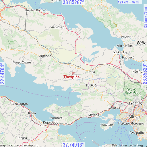
Thespiés GPS coordinates[2]
38° 18' 10.8" North, 23° 9' 0.576" East
| Map corner | latitude | longitude |
|---|---|---|
| Upper-left | 38.85267°, | 22.44704° |
| Center: | 38.303°, | 23.15016° |
| Lower-right: | 37.74913°, | 23.85329° |
| Map W x H: | 122.7×122.7 km | = 76.2×76.2mi |
| max Lat: | 41.72048° ⇑65.9% North |
| Thespiés: | 38.303° |
| min Lat: | ⇓34.1% South 34.8346° |
| min Long | Thespiés | max Long |
| 19.40494° | 23.15016° | 29.59361° |
| W 57.7%⇐ | ⇒42.3% E |
Elevation
Elevation of Thespiés is 380 m = 1247 ft, and this is 211.1 m = 693 ft above average elevation for this country.
| Max E: |
1439 m = 4721 ft | 14.7% |
| Thespiés | 380 m 1247 ft | |
| Avg. | 168.9 m = 554 ft | |
Min E: |
0 m = 0 ft | 85.3% |
See also: Greece elevation on elevation.city.
Geographical zone
Thespiés is located in North temperate zone (between Tropic of Cancer and the Arctic Circle). Distance of this Northern Tropic circle is 1653 km =1027.1 mi to South.| Distance of | km | miles | from Thespiés |
|---|---|---|---|
| North Pole | 5748.2 | 3571.8 | to North |
| Arctic Circle | 3142.3 | 1952.5 | to North |
| Tropic Cancer | 1653 | 1027.1 | to South |
| Equator | 4258.9 | 2646.4 | to South |


Nearby cities:
15 places around Thespiés: (largest is in red/bold)
• Agía Triáda
21.8 km =13.5 mi,  285°
285°
• Akraifnía
18.2 km =11.3 mi,  19°
19°
• Alíartos
8.3 km =5.2 mi,  328°
328°
• Domvraína
15.7 km =9.8 mi,  249°
249°
• Erythrés
17.8 km =11.1 mi,  122°
122°
• Kallithea - Moustafádhes
25.2 km =15.7 mi,  87°
87°
• Kaparéllion
9.2 km =5.7 mi,  142°
142°
• Kástron
21.2 km =13.2 mi,  2°
2°
• Kókkinon
20.6 km =12.8 mi, 21°
• Orchomenós
25.8 km =16 mi,  324°
324°
• Plataiés
14.3 km =8.9 mi,  134°
134°
• Thívai
14.9 km =9.3 mi,  80°
80°
• Vágia
2.9 km =1.8 mi,  56°
56°
• Vília
22.2 km =13.8 mi, 132°
• Ágios Geórgios
21.5 km =13.4 mi,  297°
297°
Sources, notices
• [Note1] Compared only with cities in Greece existing in our database
• [Src1] Map data: © OpenStreetMap contributors (CC-BY-SA)
• [Src2] Other city data from geonames.org with taken over terms of usage.
• [Src3] Geographical zone / Annual Mean Temperature by Robert A. Rohde @ Wikipedia
