Gargaliánoi geodata
Gargaliánoi (Peloponnese) is a populated place; located in Greece in Europe/Athens (GMT+3) time zone. With population of 6,282 people, there are 200 cities with bigger population in this country. Compared to other cities in Greece, 89.3% of cities are located further ↑North; 80% of cities are located further →East and 80.1% of cities have lower elevation than Gargaliánoi. Note1


Gargaliánoi GPS coordinates[2]
37° 3' 54.648" North, 21° 38' 17.124" East
| Map corner | latitude | longitude |
|---|---|---|
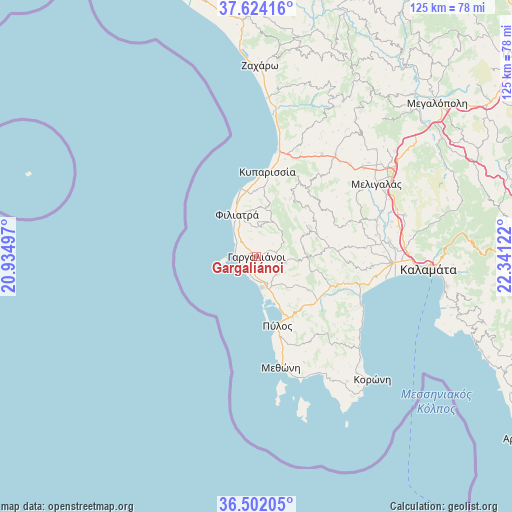
| Upper-left | 37.62416°, | 20.93497° |
| Center: | 37.06518°, | 21.63809° |
| Lower-right: | 36.50205°, | 22.34122° |
| Map W x H: | 124.8×124.8 km | = 77.5×77.5mi |
| max Lat: | 41.72048° ⇑89.3% North |
| Gargaliánoi: | 37.06518° |
| min Lat: | ⇓10.7% South 34.8346° |
| min Long | Gargaliánoi | max Long |
| 19.40494° | 21.63809° | 29.59361° |
| W 20%⇐ | ⇒80% E |
Elevation
Elevation of Gargaliánoi is 279 m = 915 ft, and this is 110.1 m = 361 ft above average elevation for this country.
| Max E: |
1439 m = 4721 ft | 19.9% |
| Gargaliánoi | 279 m 915 ft | |
| Avg. | 168.9 m = 554 ft | |
Min E: |
0 m = 0 ft | 80.1% |
See also: Greece elevation on elevation.city.
Geographical zone
Gargaliánoi is located in North temperate zone (between Tropic of Cancer and the Arctic Circle). Distance of this Northern Tropic circle is 1515.3 km =941.6 mi to South.| Distance of | km | miles | from Gargaliánoi |
|---|---|---|---|
| North Pole | 5885.8 | 3657.3 | to North |
| Arctic Circle | 3279.9 | 2038 | to North |
| Tropic Cancer | 1515.3 | 941.6 | to South |
| Equator | 4121.3 | 2560.9 | to South |


Nearby cities:
15 places around Gargaliánoi: (largest is in red/bold)
• Chóra
7.2 km =4.5 mi,  102°
102°
• Filiatrá
11.2 km =7 mi,  335°
335°
• Kopanáki
29.6 km =18.4 mi,  32°
32°
• Kyparissía
20.9 km =13 mi,  8°
8°
• Longá
32.3 km =20.1 mi,  132°
132°
• Marathópolis
5.3 km =3.3 mi,  261°
261°
• Meligalás
33.6 km =20.9 mi,  59°
59°
• Messíni
32.8 km =20.4 mi,  92°
92°
• Methóni
27.9 km =17.3 mi,  167°
167°
• Mikrománi
35 km =21.7 mi, 87°
• Pýlos
17.7 km =11 mi,  162°
162°
• Thouría
36.5 km =22.7 mi, 86°
• Valýra
32.4 km =20.1 mi,  69°
69°
• Vlachópoulo
14.1 km =8.8 mi,  105°
105°
• Áris
32.7 km =20.3 mi,  83°
83°
Sources, notices
• [Note1] Compared only with cities in Greece existing in our database
• [Src1] Map data: © OpenStreetMap contributors (CC-BY-SA)
• [Src2] Other city data from geonames.org with taken over terms of usage.
• [Src3] Geographical zone / Annual Mean Temperature by Robert A. Rohde @ Wikipedia
