Methóni geodata
Methóni (Peloponnese) is a populated place; located in Greece in Europe/Athens (GMT+3) time zone. With population of 1,165 people, there are 854 cities with bigger population in this country. Compared to other cities in Greece, 91.2% of cities are located further ↑North; 78.2% of cities are located further →East and 77.6% of cities have higher elevation than Methóni. Note1
Administrative division(s):
- Level 1: Peloponnese
- Level 2: Nomós Messinías
- Level 3: Dimos Pylos-Nestoras


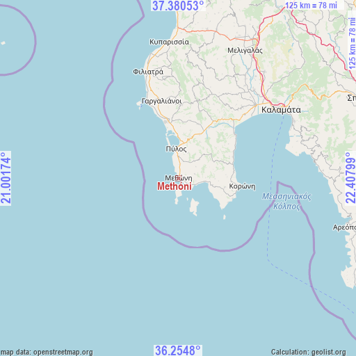
Methóni GPS coordinates[2]
36° 49' 11.028" North, 21° 42' 17.496" East
| Map corner | latitude | longitude |
|---|---|---|
| Upper-left | 37.38053°, | 21.00174° |
| Center: | 36.81973°, | 21.70486° |
| Lower-right: | 36.2548°, | 22.40799° |
| Map W x H: | 125.2×125.2 km | = 77.8×77.8mi |
| max Lat: | 41.72048° ⇑91.2% North |
| Methóni: | 36.81973° |
| min Lat: | ⇓8.8% South 34.8346° |
| min Long | Methóni | max Long |
| 19.40494° | 21.70486° | 29.59361° |
| W 21.8%⇐ | ⇒78.2% E |
Elevation
Elevation of Methóni is 20 m = 66 ft, and this is 148.9 m = 489 ft below average elevation for this country.
| Max E: |
1439 m = 4721 ft | 77.6% |
| Avg. | 168.9 m = 554 ft | |
| Methóni | 20 m = 66 ft | |
Min E: |
0 m = 0 ft | 22.4% |
See also: Greece elevation on elevation.city.
Geographical zone
Methóni is located in North temperate zone (between Tropic of Cancer and the Arctic Circle). Distance of this Northern Tropic circle is 1488.1 km =924.7 mi to South.| Distance of | km | miles | from Methóni |
|---|---|---|---|
| North Pole | 5913.1 | 3674.2 | to North |
| Arctic Circle | 3307.2 | 2055 | to North |
| Tropic Cancer | 1488.1 | 924.7 | to South |
| Equator | 4094 | 2543.9 | to South |


Nearby cities:
15 places around Methóni: (largest is in red/bold)
• Asprókhoma
41.5 km =25.8 mi,  52°
52°
• Chóra
25.7 km =16 mi,  2°
2°
• Filiatrá
38.9 km =24.2 mi,  344°
344°
• Gargaliánoi
27.9 km =17.3 mi,  347°
347°
• Kalamata
43.7 km =27.2 mi,  56°
56°
• Koróni
22.7 km =14.1 mi,  96°
96°
• Longá
18.8 km =11.7 mi,  73°
73°
• Marathópolis
28.8 km =17.9 mi, 337°
• Messíni
37.2 km =23.1 mi, 46°
• Mikrománi
40.8 km =25.4 mi, 45°
• Pýlos
10.4 km =6.5 mi,  355°
355°
• Sperchógeia
42.5 km =26.4 mi, 48°
• Thouría
42.4 km =26.3 mi, 46°
• Vlachópoulo
24.8 km =15.4 mi,  18°
18°
• Áris
40.9 km =25.4 mi,  40°
40°
Sources, notices
• [Note1] Compared only with cities in Greece existing in our database
• [Src1] Map data: © OpenStreetMap contributors (CC-BY-SA)
• [Src2] Other city data from geonames.org with taken over terms of usage.
• [Src3] Geographical zone / Annual Mean Temperature by Robert A. Rohde @ Wikipedia
