Filiatrá geodata
Filiatrá (Peloponnese) is a populated place; located in Greece in Europe/Athens (GMT+3) time zone. With population of 6,970 people, there are 184 cities with bigger population in this country. Compared to other cities in Greece, 88.3% of cities are located further ↑North; 81.5% of cities are located further →East and 54.3% of cities have higher elevation than Filiatrá. Note1


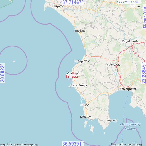
Filiatrá GPS coordinates[2]
37° 9' 22.932" North, 21° 35' 7.152" East
| Map corner | latitude | longitude |
|---|---|---|
| Upper-left | 37.71467°, | 20.8822° |
| Center: | 37.15637°, | 21.58532° |
| Lower-right: | 36.59391°, | 22.28845° |
| Map W x H: | 124.6×124.6 km | = 77.4×77.4mi |
| max Lat: | 41.72048° ⇑88.3% North |
| Filiatrá: | 37.15637° |
| min Lat: | ⇓11.7% South 34.8346° |
| min Long | Filiatrá | max Long |
| 19.40494° | 21.58532° | 29.59361° |
| W 18.5%⇐ | ⇒81.5% E |
Elevation
Elevation of Filiatrá is 67 m = 220 ft, and this is 101.9 m = 334 ft below average elevation for this country.
| Max E: |
1439 m = 4721 ft | 54.3% |
| Avg. | 168.9 m = 554 ft | |
| Filiatrá | 67 m = 220 ft | |
Min E: |
0 m = 0 ft | 45.7% |
See also: Greece elevation on elevation.city.
Geographical zone
Filiatrá is located in North temperate zone (between Tropic of Cancer and the Arctic Circle). Distance of this Northern Tropic circle is 1525.5 km =947.9 mi to South.| Distance of | km | miles | from Filiatrá |
|---|---|---|---|
| North Pole | 5875.7 | 3651 | to North |
| Arctic Circle | 3269.8 | 2031.8 | to North |
| Tropic Cancer | 1525.5 | 947.9 | to South |
| Equator | 4131.4 | 2567.1 | to South |


Nearby cities:
15 places around Filiatrá: (largest is in red/bold)
• Arfará
40.7 km =25.3 mi,  90°
90°
• Chóra
16.5 km =10.3 mi,  135°
135°
• Gargaliánoi
11.2 km =7 mi,  155°
155°
• Kopanáki
25.4 km =15.8 mi,  54°
54°
• Kyparissía
13.1 km =8.1 mi,  36°
36°
• Marathópolis
11 km =6.8 mi,  182°
182°
• Meligalás
34.4 km =21.4 mi,  78°
78°
• Messíni
39.2 km =24.4 mi,  107°
107°
• Methóni
38.9 km =24.2 mi, 164°
• Mikrománi
40.6 km =25.2 mi,  102°
102°
• Pýlos
28.8 km =17.9 mi, 159°
• Valýra
35.1 km =21.8 mi, 88°
• Vlachópoulo
22.9 km =14.2 mi,  127°
127°
• Zacháro
36.8 km =22.9 mi,  8°
8°
• Áris
37.7 km =23.4 mi, 99°
Sources, notices
• [Note1] Compared only with cities in Greece existing in our database
• [Src1] Map data: © OpenStreetMap contributors (CC-BY-SA)
• [Src2] Other city data from geonames.org with taken over terms of usage.
• [Src3] Geographical zone / Annual Mean Temperature by Robert A. Rohde @ Wikipedia
