Fry geodata
Fry (South Aegean) is a seat of a third-order administrative division; located in Greece in Europe/Athens (GMT+3) time zone. With population of 357 people, there are 1810 cities with bigger population in this country. Compared to other cities in Greece, 94.9% of cities are located further ↑North; 98.2% of cities are located further ←West and 85.7% of cities have higher elevation than Fry. Note1


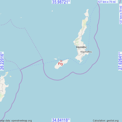
Fry GPS coordinates[2]
35° 24' 58.428" North, 26° 55' 23.808" East
| Map corner | latitude | longitude |
|---|---|---|
| Upper-left | 35.98721°, | 26.22016° |
| Center: | 35.41623°, | 26.92328° |
| Lower-right: | 34.84118°, | 27.62641° |
| Map W x H: | 127.4×127.4 km | = 79.2×79.2mi |
| max Lat: | 41.72048° ⇑94.9% North |
| Fry: | 35.41623° |
| min Lat: | ⇓5.1% South 34.8346° |
| min Long | Fry | max Long |
| 19.40494° | 26.92328° | 29.59361° |
| W 98.2%⇐ | ⇒1.8% E |
Elevation
Elevation of Fry is 12 m = 39 ft, and this is 156.9 m = 515 ft below average elevation for this country.
| Max E: |
1439 m = 4721 ft | 85.7% |
| Avg. | 168.9 m = 554 ft | |
| Fry | 12 m = 39 ft | |
Min E: |
0 m = 0 ft | 14.3% |
See also: Greece elevation on elevation.city.
Geographical zone
Fry is located in North temperate zone (between Tropic of Cancer and the Arctic Circle). Distance of this Northern Tropic circle is 1332 km =827.7 mi to South.| Distance of | km | miles | from Fry |
|---|---|---|---|
| North Pole | 6069.1 | 3771.2 | to North |
| Arctic Circle | 3463.3 | 2152 | to North |
| Tropic Cancer | 1332 | 827.7 | to South |
| Equator | 3937.9 | 2446.9 | to South |


Nearby cities:
15 places around Fry: (largest is in red/bold)
• Análipsi
95.3 km =59.2 mi,  243°
243°
• Chálki
109 km =67.7 mi,  34°
34°
• Eloúnda
110.3 km =68.5 mi,  261°
261°
• Férma
106.7 km =66.3 mi,  245°
245°
• Karpathos
28.1 km =17.5 mi,  68°
68°
• Kavoúsi
102.1 km =63.4 mi, 251°
• Koutsounári
108.9 km =67.7 mi, 245°
• Koutsourás
98.3 km =61.1 mi, 244°
• Káto Chorió
110.7 km =68.8 mi, 248°
• Makry-Gialos
96.2 km =59.8 mi, 244°
• Pacheía Ámmos
106.8 km =66.4 mi, 251°
• Palekastro
65.4 km =40.6 mi, 248°
• Schísma Eloúndas
109.8 km =68.2 mi, 260°
• Sitia
77.8 km =48.3 mi, 252°
• Ístro
112.3 km =69.8 mi, 253°
Sources, notices
• [Note1] Compared only with cities in Greece existing in our database
• [Src1] Map data: © OpenStreetMap contributors (CC-BY-SA)
• [Src2] Other city data from geonames.org with taken over terms of usage.
• [Src3] Geographical zone / Annual Mean Temperature by Robert A. Rohde @ Wikipedia
