Epinianá geodata
Epinianá (Central Greece) is a populated place; located in Greece in Europe/Athens (GMT+3) time zone. With population of 683 people, there are 1436 cities with bigger population in this country. Compared to other cities in Greece, 52.1% of cities are located further ↑North; 81% of cities are located further →East and 98.9% of cities have lower elevation than Epinianá. Note1


Epinianá GPS coordinates[2]
39° 8' 32.316" North, 21° 36' 48.708" East
| Map corner | latitude | longitude |
|---|---|---|
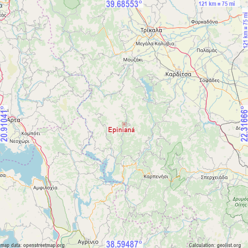
| Upper-left | 39.68553°, | 20.91041° |
| Center: | 39.14231°, | 21.61353° |
| Lower-right: | 38.59487°, | 22.31666° |
| Map W x H: | 121.3×121.3 km | = 75.4×75.4mi |
| max Lat: | 41.72048° ⇑52.1% North |
| Epinianá: | 39.14231° |
| min Lat: | ⇓47.9% South 34.8346° |
| min Long | Epinianá | max Long |
| 19.40494° | 21.61353° | 29.59361° |
| W 19%⇐ | ⇒81% E |
Elevation
Elevation of Epinianá is 932 m = 3058 ft, and this is 763.1 m = 2504 ft above average elevation for this country.
| Max E: |
1439 m = 4721 ft | 1.1% |
| Epinianá | 932 m 3058 ft | |
| Avg. | 168.9 m = 554 ft | |
Min E: |
0 m = 0 ft | 98.9% |
See also: Greece elevation on elevation.city.
Geographical zone
Epinianá is located in North temperate zone (between Tropic of Cancer and the Arctic Circle). Distance of this Northern Tropic circle is 1746.3 km =1085.1 mi to South.| Distance of | km | miles | from Epinianá |
|---|---|---|---|
| North Pole | 5654.8 | 3513.7 | to North |
| Arctic Circle | 3049 | 1894.6 | to North |
| Tropic Cancer | 1746.3 | 1085.1 | to South |
| Equator | 4352.2 | 2704.3 | to South |


Nearby cities:
15 places around Epinianá: (largest is in red/bold)
• Anthiró
26.4 km =16.4 mi,  329°
329°
• Drakótrypa
28.4 km =17.6 mi,  357°
357°
• Empesós
28.6 km =17.8 mi,  242°
242°
• Fourná
24.4 km =15.2 mi,  112°
112°
• Kallíthiro
29.5 km =18.3 mi,  58°
58°
• Kerasochóri
15.3 km =9.5 mi,  172°
172°
• Mitrópoli
29.2 km =18.1 mi,  41°
41°
• Morfovoúni
26.2 km =16.3 mi,  26°
26°
• Neochóri
17.9 km =11.1 mi, 34°
• Perdikáki
24 km =14.9 mi, 244°
• Raptópoulo
11.5 km =7.1 mi,  273°
273°
• Vatsouniá
29.8 km =18.5 mi, 355°
• Xinonéri
28.9 km =18 mi,  47°
47°
• Ágios Geórgios
25.7 km =16 mi, 48°
• Ágrafa
3.1 km =1.9 mi,  101°
101°
Sources, notices
• [Note1] Compared only with cities in Greece existing in our database
• [Src1] Map data: © OpenStreetMap contributors (CC-BY-SA)
• [Src2] Other city data from geonames.org with taken over terms of usage.
• [Src3] Geographical zone / Annual Mean Temperature by Robert A. Rohde @ Wikipedia
