Raptópoulo geodata
Raptópoulo (Central Greece) is a populated place; located in Greece in Europe/Athens (GMT+3) time zone. With population of 528 people, there are 1746 cities with bigger population in this country. Compared to other cities in Greece, 51.8% of cities are located further ↑North; 83.4% of cities are located further →East and 97.8% of cities have lower elevation than Raptópoulo. Note1


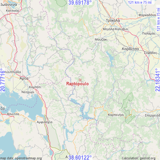
Raptópoulo GPS coordinates[2]
39° 8' 54.996" North, 21° 28' 49.008" East
| Map corner | latitude | longitude |
|---|---|---|
| Upper-left | 39.69178°, | 20.77716° |
| Center: | 39.14861°, | 21.48028° |
| Lower-right: | 38.60122°, | 22.18341° |
| Map W x H: | 121.3×121.3 km | = 75.4×75.4mi |
| max Lat: | 41.72048° ⇑51.8% North |
| Raptópoulo: | 39.14861° |
| min Lat: | ⇓48.2% South 34.8346° |
| min Long | Raptópoulo | max Long |
| 19.40494° | 21.48028° | 29.59361° |
| W 16.6%⇐ | ⇒83.4% E |
Elevation
Elevation of Raptópoulo is 831 m = 2726 ft, and this is 662.1 m = 2172 ft above average elevation for this country.
| Max E: |
1439 m = 4721 ft | 2.2% |
| Raptópoulo | 831 m 2726 ft | |
| Avg. | 168.9 m = 554 ft | |
Min E: |
0 m = 0 ft | 97.8% |
See also: Greece elevation on elevation.city.
Geographical zone
Raptópoulo is located in North temperate zone (between Tropic of Cancer and the Arctic Circle). Distance of this Northern Tropic circle is 1747 km =1085.5 mi to South.| Distance of | km | miles | from Raptópoulo |
|---|---|---|---|
| North Pole | 5654.1 | 3513.3 | to North |
| Arctic Circle | 3048.3 | 1894.1 | to North |
| Tropic Cancer | 1747 | 1085.5 | to South |
| Equator | 4352.9 | 2704.8 | to South |


Nearby cities:
15 places around Raptópoulo: (largest is in red/bold)
• Anthiró
22.2 km =13.8 mi,  355°
355°
• Drakótrypa
29.5 km =18.3 mi,  20°
20°
• Empesós
19.6 km =12.2 mi,  224°
224°
• Epinianá
11.5 km =7.1 mi,  93°
93°
• Kerasochóri
20.9 km =13 mi,  139°
139°
• Kríkellos
34.5 km =21.4 mi,  229°
229°
• Menídi
33.4 km =20.8 mi,  249°
249°
• Morfovoúni
32.5 km =20.2 mi,  45°
45°
• Neochóri
25.8 km =16 mi,  57°
57°
• Perdikáki
15 km =9.3 mi, 222°
• Pétra
31.7 km =19.7 mi,  273°
273°
• Stournaraíïka
33.9 km =21.1 mi,  1°
1°
• Vatsouniá
30.4 km =18.9 mi, 17°
• Ágrafa
14.6 km =9.1 mi,  95°
95°
• Áno Kalentíni
27.8 km =17.3 mi,  293°
293°
Sources, notices
• [Note1] Compared only with cities in Greece existing in our database
• [Src1] Map data: © OpenStreetMap contributors (CC-BY-SA)
• [Src2] Other city data from geonames.org with taken over terms of usage.
• [Src3] Geographical zone / Annual Mean Temperature by Robert A. Rohde @ Wikipedia
