Kerasochóri geodata
Kerasochóri (Central Greece) is a seat of a third-order administrative division; located in Greece in Europe/Athens (GMT+3) time zone. With population of 274 people, there are 1813 cities with bigger population in this country. Compared to other cities in Greece, 54.4% of cities are located further ↑North; 80.1% of cities are located further →East and 99.7% of cities have lower elevation than Kerasochóri. Note1


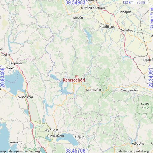
Kerasochóri GPS coordinates[2]
39° 0' 20.016" North, 21° 38' 16.008" East
| Map corner | latitude | longitude |
|---|---|---|
| Upper-left | 39.54983°, | 20.93466° |
| Center: | 39.00556°, | 21.63778° |
| Lower-right: | 38.45706°, | 22.34091° |
| Map W x H: | 121.5×121.5 km | = 75.5×75.5mi |
| max Lat: | 41.72048° ⇑54.4% North |
| Kerasochóri: | 39.00556° |
| min Lat: | ⇓45.6% South 34.8346° |
| min Long | Kerasochóri | max Long |
| 19.40494° | 21.63778° | 29.59361° |
| W 19.9%⇐ | ⇒80.1% E |
Elevation
Elevation of Kerasochóri is 1012 m = 3320 ft, and this is 843.1 m = 2766 ft above average elevation for this country.
| Max E: |
1439 m = 4721 ft | 0.3% |
| Kerasochóri | 1012 m 3320 ft | |
| Avg. | 168.9 m = 554 ft | |
Min E: |
0 m = 0 ft | 99.7% |
See also: Greece elevation on elevation.city.
Geographical zone
Kerasochóri is located in North temperate zone (between Tropic of Cancer and the Arctic Circle). Distance of this Northern Tropic circle is 1731.1 km =1075.7 mi to South.| Distance of | km | miles | from Kerasochóri |
|---|---|---|---|
| North Pole | 5670.1 | 3523.2 | to North |
| Arctic Circle | 3064.2 | 1904 | to North |
| Tropic Cancer | 1731.1 | 1075.7 | to South |
| Equator | 4337 | 2694.9 | to South |


Nearby cities:
15 places around Kerasochóri: (largest is in red/bold)
• Empesós
27.6 km =17.1 mi,  274°
274°
• Epinianá
15.3 km =9.5 mi,  352°
352°
• Fourná
21.4 km =13.3 mi,  73°
73°
• Ftéri
37.2 km =23.1 mi,  108°
108°
• Kallíthiro
38.3 km =23.8 mi,  36°
36°
• Karpenísi
17.3 km =10.7 mi,  126°
126°
• Neochóri
30.9 km =19.2 mi,  15°
15°
• Palioúri
38.1 km =23.7 mi,  51°
51°
• Perdikáki
24.2 km =15 mi,  281°
281°
• Raptópoulo
20.9 km =13 mi,  319°
319°
• Rentína
30.2 km =18.8 mi,  77°
77°
• Sardínia
39.5 km =24.5 mi,  251°
251°
• Xinonéri
39.7 km =24.7 mi,  28°
28°
• Ágios Geórgios
36.6 km =22.7 mi, 27°
• Ágrafa
14.6 km =9.1 mi,  3°
3°
Sources, notices
• [Note1] Compared only with cities in Greece existing in our database
• [Src1] Map data: © OpenStreetMap contributors (CC-BY-SA)
• [Src2] Other city data from geonames.org with taken over terms of usage.
• [Src3] Geographical zone / Annual Mean Temperature by Robert A. Rohde @ Wikipedia
