Perdikáki geodata
Perdikáki (West Greece) is a populated place; located in Greece in Europe/Athens (GMT+3) time zone. With population of 517 people, there are 1774 cities with bigger population in this country. Compared to other cities in Greece, 54% of cities are located further ↑North; 85.1% of cities are located further →East and 96% of cities have lower elevation than Perdikáki. Note1
Administrative division(s):
- Level 1: West Greece
- Level 2: Nomós Aitolías kai Akarnanías
- Level 3: Dimos Amfilochia


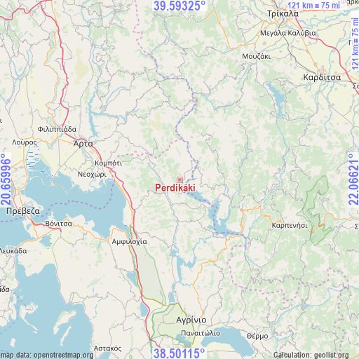
Perdikáki GPS coordinates[2]
39° 2' 57.516" North, 21° 21' 47.088" East
| Map corner | latitude | longitude |
|---|---|---|
| Upper-left | 39.59325°, | 20.65996° |
| Center: | 39.04931°, | 21.36308° |
| Lower-right: | 38.50115°, | 22.06621° |
| Map W x H: | 121.4×121.4 km | = 75.4×75.4mi |
| max Lat: | 41.72048° ⇑54% North |
| Perdikáki: | 39.04931° |
| min Lat: | ⇓46% South 34.8346° |
| min Long | Perdikáki | max Long |
| 19.40494° | 21.36308° | 29.59361° |
| W 14.9%⇐ | ⇒85.1% E |
Elevation
Elevation of Perdikáki is 713 m = 2339 ft, and this is 544.1 m = 1785 ft above average elevation for this country.
| Max E: |
1439 m = 4721 ft | 4% |
| Perdikáki | 713 m 2339 ft | |
| Avg. | 168.9 m = 554 ft | |
Min E: |
0 m = 0 ft | 96% |
See also: Greece elevation on elevation.city.
Geographical zone
Perdikáki is located in North temperate zone (between Tropic of Cancer and the Arctic Circle). Distance of this Northern Tropic circle is 1736 km =1078.7 mi to South.| Distance of | km | miles | from Perdikáki |
|---|---|---|---|
| North Pole | 5665.2 | 3520.2 | to North |
| Arctic Circle | 3059.3 | 1901 | to North |
| Tropic Cancer | 1736 | 1078.7 | to South |
| Equator | 4341.9 | 2697.9 | to South |


Nearby cities:
15 places around Perdikáki: (largest is in red/bold)
• Amfilochía
27.1 km =16.8 mi,  218°
218°
• Boúka
23.5 km =14.6 mi,  234°
234°
• Empesós
4.7 km =2.9 mi, 232°
• Epinianá
24 km =14.9 mi,  64°
64°
• Kerasochóri
24.2 km =15 mi,  101°
101°
• Kompóti
24.8 km =15.4 mi,  283°
283°
• Kríkellos
19.7 km =12.2 mi, 233°
• Megárchi
27.1 km =16.8 mi,  291°
291°
• Menídi
21.1 km =13.1 mi,  267°
267°
• Pétra
25.2 km =15.7 mi,  301°
301°
• Raptópoulo
15 km =9.3 mi,  42°
42°
• Sardínia
22.3 km =13.9 mi, 217°
• Selládes
25.5 km =15.8 mi, 285°
• Ágrafa
26.5 km =16.5 mi,  68°
68°
• Áno Kalentíni
27.1 km =16.8 mi,  325°
325°
Sources, notices
• [Note1] Compared only with cities in Greece existing in our database
• [Src1] Map data: © OpenStreetMap contributors (CC-BY-SA)
• [Src2] Other city data from geonames.org with taken over terms of usage.
• [Src3] Geographical zone / Annual Mean Temperature by Robert A. Rohde @ Wikipedia
