Zacháro geodata
Zacháro (West Greece) is a seat of a third-order administrative division; located in Greece in Europe/Athens (GMT+3) time zone. With population of 5,894 people, there are 208 cities with bigger population in this country. Compared to other cities in Greece, 86.1% of cities are located further ↑North; 79.8% of cities are located further →East and 80.3% of cities have higher elevation than Zacháro. Note1


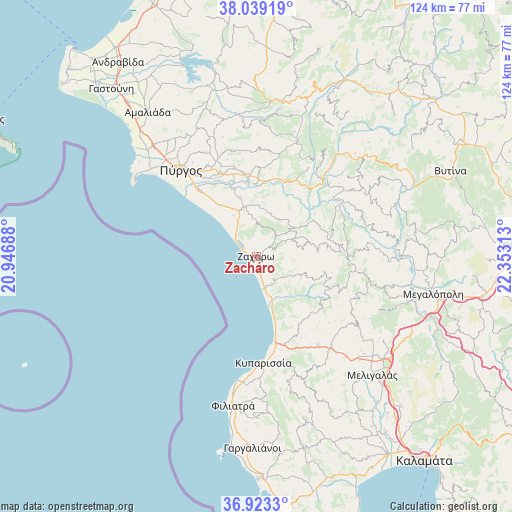
Zacháro GPS coordinates[2]
37° 28' 59.988" North, 21° 39' 0" East
| Map corner | latitude | longitude |
|---|---|---|
| Upper-left | 38.03919°, | 20.94688° |
| Center: | 37.48333°, | 21.65° |
| Lower-right: | 36.9233°, | 22.35313° |
| Map W x H: | 124.1×124.1 km | = 77.1×77.1mi |
| max Lat: | 41.72048° ⇑86.1% North |
| Zacháro: | 37.48333° |
| min Lat: | ⇓13.9% South 34.8346° |
| min Long | Zacháro | max Long |
| 19.40494° | 21.65° | 29.59361° |
| W 20.2%⇐ | ⇒79.8% E |
Elevation
Elevation of Zacháro is 17 m = 56 ft, and this is 151.9 m = 498 ft below average elevation for this country.
| Max E: |
1439 m = 4721 ft | 80.3% |
| Avg. | 168.9 m = 554 ft | |
| Zacháro | 17 m = 56 ft | |
Min E: |
0 m = 0 ft | 19.7% |
See also: Greece elevation on elevation.city.
Geographical zone
Zacháro is located in North temperate zone (between Tropic of Cancer and the Arctic Circle). Distance of this Northern Tropic circle is 1561.8 km =970.5 mi to South.| Distance of | km | miles | from Zacháro |
|---|---|---|---|
| North Pole | 5839.3 | 3628.4 | to North |
| Arctic Circle | 3233.4 | 2009.1 | to North |
| Tropic Cancer | 1561.8 | 970.5 | to South |
| Equator | 4167.8 | 2589.8 | to South |


Nearby cities:
15 places around Zacháro: (largest is in red/bold)
• Alfeioúsa
20.1 km =12.5 mi,  330°
330°
• Andrítsaina
22.6 km =14 mi,  89°
89°
• Archaía Olympía
18.4 km =11.4 mi,  353°
353°
• Epitálio
21 km =13 mi,  319°
319°
• Kallithéa
16.8 km =10.4 mi,  63°
63°
• Kopanáki
26.2 km =16.3 mi,  145°
145°
• Kréstena
12.4 km =7.7 mi, 347°
• Kyparissía
25.9 km =16.1 mi,  175°
175°
• Lálas
25.9 km =16.1 mi,  14°
14°
• Makrísia
14.6 km =9.1 mi,  344°
344°
• Pelópi
21.8 km =13.5 mi, 346°
• Plátanos
20.7 km =12.9 mi, 350°
• Pýrgos
28.2 km =17.5 mi, 319°
• Varvásaina
24.8 km =15.4 mi, 327°
• Vrína
9.6 km =6 mi, 353°
Sources, notices
• [Note1] Compared only with cities in Greece existing in our database
• [Src1] Map data: © OpenStreetMap contributors (CC-BY-SA)
• [Src2] Other city data from geonames.org with taken over terms of usage.
• [Src3] Geographical zone / Annual Mean Temperature by Robert A. Rohde @ Wikipedia
