Irákleia geodata
Irákleia (Central Macedonia) is a seat of a third-order administrative division; located in Greece in Europe/Athens (GMT+3) time zone. With population of 3,786 people, there are 290 cities with bigger population in this country. Compared to other cities in Greece, 97.3% of cities are located further ↓South; 60% of cities are located further ←West and 65.2% of cities have higher elevation than Irákleia. Note1
Administrative division(s):
- Level 1: Central Macedonia
- Level 2: Nomós Serrón
- Level 3: Dimos Irakleia


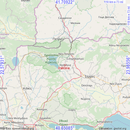
Irákleia GPS coordinates[2]
41° 10' 55.812" North, 23° 16' 56.748" East
| Map corner | latitude | longitude |
|---|---|---|
| Upper-left | 41.70922°, | 22.57931° |
| Center: | 41.18217°, | 23.28243° |
| Lower-right: | 40.65085°, | 23.98556° |
| Map W x H: | 117.7×117.7 km | = 73.1×73.1mi |
| max Lat: | 41.72048° ⇑2.7% North |
| Irákleia: | 41.18217° |
| min Lat: | ⇓97.3% South 34.8346° |
| min Long | Irákleia | max Long |
| 19.40494° | 23.28243° | 29.59361° |
| W 60%⇐ | ⇒40% E |
Elevation
Elevation of Irákleia is 39 m = 128 ft, and this is 129.9 m = 426 ft below average elevation for this country.
| Max E: |
1439 m = 4721 ft | 65.2% |
| Avg. | 168.9 m = 554 ft | |
| Irákleia | 39 m = 128 ft | |
Min E: |
0 m = 0 ft | 34.8% |
See also: Greece elevation on elevation.city.
Geographical zone
Irákleia is located in North temperate zone (between Tropic of Cancer and the Arctic Circle). Distance of this Northern Tropic circle is 1973.1 km =1226 mi to South.| Distance of | km | miles | from Irákleia |
|---|---|---|---|
| North Pole | 5428 | 3372.8 | to North |
| Arctic Circle | 2822.1 | 1753.6 | to North |
| Tropic Cancer | 1973.1 | 1226 | to South |
| Equator | 4579 | 2845.3 | to South |


Nearby cities:
15 places around Irákleia: (largest is in red/bold)
• Ammoudhiá
6.2 km =3.9 mi,  134°
134°
• Anayénnisis
9.1 km =5.7 mi,  152°
152°
• Cheímarros
8.2 km =5.1 mi,  194°
194°
• Chorteró
8.3 km =5.2 mi,  60°
60°
• Chrysochórafa
3.9 km =2.4 mi,  268°
268°
• Dasochóri
2.4 km =1.5 mi,  210°
210°
• Gefyroúdi
7.1 km =4.4 mi,  110°
110°
• Karperí
5.9 km =3.7 mi,  161°
161°
• Koímisi
3.7 km =2.3 mi,  23°
23°
• Limnochóri
7 km =4.3 mi,  292°
292°
• Lithótopos
7.4 km =4.6 mi,  223°
223°
• Megalochóri
8.7 km =5.4 mi,  326°
326°
• Pontisméno
3 km =1.9 mi,  1°
1°
• Valteró
3.2 km =2 mi,  95°
95°
• Vamvakófyto
9.5 km =5.9 mi,  92°
92°
Sources, notices
• [Note1] Compared only with cities in Greece existing in our database
• [Src1] Map data: © OpenStreetMap contributors (CC-BY-SA)
• [Src2] Other city data from geonames.org with taken over terms of usage.
• [Src3] Geographical zone / Annual Mean Temperature by Robert A. Rohde @ Wikipedia
