Dasochóri geodata
Dasochóri (Central Macedonia) is a populated place; located in Greece in Europe/Athens (GMT+3) time zone. With population of 834 people, there are 1224 cities with bigger population in this country. Compared to other cities in Greece, 97% of cities are located further ↓South; 59.7% of cities are located further ←West and 68.3% of cities have higher elevation than Dasochóri. Note1
Administrative division(s):
- Level 1: Central Macedonia
- Level 2: Nomós Serrón
- Level 3: Dimos Irakleia


Dasochóri GPS coordinates[2]
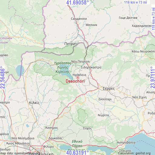
41° 9' 48.168" North, 23° 16' 4.728" East
| Map corner | latitude | longitude |
|---|---|---|
| Upper-left | 41.69058°, | 22.56486° |
| Center: | 41.16338°, | 23.26798° |
| Lower-right: | 40.63191°, | 23.97111° |
| Map W x H: | 117.7×117.7 km | = 73.1×73.1mi |
| max Lat: | 41.72048° ⇑3% North |
| Dasochóri: | 41.16338° |
| min Lat: | ⇓97% South 34.8346° |
| min Long | Dasochóri | max Long |
| 19.40494° | 23.26798° | 29.59361° |
| W 59.7%⇐ | ⇒40.3% E |
Elevation
Elevation of Dasochóri is 34 m = 112 ft, and this is 134.9 m = 443 ft below average elevation for this country.
| Max E: |
1439 m = 4721 ft | 68.3% |
| Avg. | 168.9 m = 554 ft | |
| Dasochóri | 34 m = 112 ft | |
Min E: |
0 m = 0 ft | 31.7% |
See also: Greece elevation on elevation.city.
Geographical zone
Dasochóri is located in North temperate zone (between Tropic of Cancer and the Arctic Circle). Distance of this Northern Tropic circle is 1971 km =1224.7 mi to South.| Distance of | km | miles | from Dasochóri |
|---|---|---|---|
| North Pole | 5430.1 | 3374.1 | to North |
| Arctic Circle | 2824.2 | 1754.9 | to North |
| Tropic Cancer | 1971 | 1224.7 | to South |
| Equator | 4576.9 | 2844 | to South |


Nearby cities:
15 places around Dasochóri: (largest is in red/bold)
• Ammoudhiá
6.1 km =3.8 mi,  111°
111°
• Anayénnisis
8 km =5 mi,  137°
137°
• Cheímarros
5.9 km =3.7 mi,  187°
187°
• Chorteró
10.5 km =6.5 mi,  53°
53°
• Chrysochórafa
3.3 km =2.1 mi,  305°
305°
• Gefyroúdi
7.8 km =4.8 mi,  93°
93°
• Irákleia
2.4 km =1.5 mi,  30°
30°
• Karperí
4.6 km =2.9 mi, 138°
• Koímisi
6.1 km =3.8 mi, 26°
• Limnochóri
7.1 km =4.4 mi, 311°
• Lithótopos
5 km =3.1 mi,  230°
230°
• Megalochóri
10 km =6.2 mi,  338°
338°
• Pontisméno
5.2 km =3.2 mi,  14°
14°
• Skotoússa
10.3 km =6.4 mi, 112°
• Valteró
4.7 km =2.9 mi,  67°
67°
Sources, notices
• [Note1] Compared only with cities in Greece existing in our database
• [Src1] Map data: © OpenStreetMap contributors (CC-BY-SA)
• [Src2] Other city data from geonames.org with taken over terms of usage.
• [Src3] Geographical zone / Annual Mean Temperature by Robert A. Rohde @ Wikipedia
