Charopó geodata
Charopó (Central Macedonia) is a populated place; located in Greece in Europe/Athens (GMT+3) time zone. With population of 1,042 people, there are 971 cities with bigger population in this country. Compared to other cities in Greece, 98.4% of cities are located further ↓South; 61.7% of cities are located further ←West and 59.3% of cities have lower elevation than Charopó. Note1


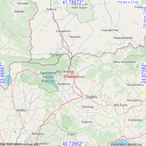
Charopó GPS coordinates[2]
41° 15' 37.116" North, 23° 22' 22.044" East
| Map corner | latitude | longitude |
|---|---|---|
| Upper-left | 41.78672°, | 22.66967° |
| Center: | 41.26031°, | 23.37279° |
| Lower-right: | 40.72962°, | 24.07592° |
| Map W x H: | 117.5×117.5 km | = 73×73mi |
| max Lat: | 41.72048° ⇑1.6% North |
| Charopó: | 41.26031° |
| min Lat: | ⇓98.4% South 34.8346° |
| min Long | Charopó | max Long |
| 19.40494° | 23.37279° | 29.59361° |
| W 61.7%⇐ | ⇒38.3% E |
Elevation
Elevation of Charopó is 114 m = 374 ft, and this is 54.9 m = 180 ft below average elevation for this country.
| Max E: |
1439 m = 4721 ft | 40.7% |
| Avg. | 168.9 m = 554 ft | |
| Charopó | 114 m = 374 ft | |
Min E: |
0 m = 0 ft | 59.3% |
See also: Greece elevation on elevation.city.
Geographical zone
Charopó is located in North temperate zone (between Tropic of Cancer and the Arctic Circle). Distance of this Northern Tropic circle is 1981.8 km =1231.4 mi to South.| Distance of | km | miles | from Charopó |
|---|---|---|---|
| North Pole | 5419.3 | 3367.4 | to North |
| Arctic Circle | 2813.5 | 1748.2 | to North |
| Tropic Cancer | 1981.8 | 1231.4 | to South |
| Equator | 4587.7 | 2850.7 | to South |


Nearby cities:
15 places around Charopó: (largest is in red/bold)
• Ammoudhiá
13.4 km =8.3 mi,  193°
193°
• Chorteró
4.6 km =2.9 mi,  184°
184°
• Dasochóri
13.9 km =8.6 mi,  219°
219°
• Gefyroúdi
11.3 km =7 mi, 184°
• Irákleia
11.5 km =7.1 mi, 221°
• Koímisi
8 km =5 mi,  228°
228°
• Megalochóri
12.5 km =7.8 mi,  263°
263°
• Melenikítsi
13.8 km =8.6 mi,  154°
154°
• Néo Petrítsi
6.8 km =4.2 mi,  283°
283°
• Palaiókastro
12 km =7.5 mi,  163°
163°
• Pontisméno
9.4 km =5.8 mi, 232°
• Sidirókastro
3.1 km =1.9 mi, 154°
• Valteró
10 km =6.2 mi,  206°
206°
• Vamvakófyto
9.2 km =5.7 mi,  167°
167°
• Vyróneia
10.1 km =6.3 mi,  273°
273°
Sources, notices
• [Note1] Compared only with cities in Greece existing in our database
• [Src1] Map data: © OpenStreetMap contributors (CC-BY-SA)
• [Src2] Other city data from geonames.org with taken over terms of usage.
• [Src3] Geographical zone / Annual Mean Temperature by Robert A. Rohde @ Wikipedia
