Chorteró geodata
Chorteró (Central Macedonia) is a populated place; located in Greece in Europe/Athens (GMT+3) time zone. With population of 628 people, there are 1530 cities with bigger population in this country. Compared to other cities in Greece, 97.9% of cities are located further ↓South; 61.6% of cities are located further ←West and 57.4% of cities have higher elevation than Chorteró. Note1


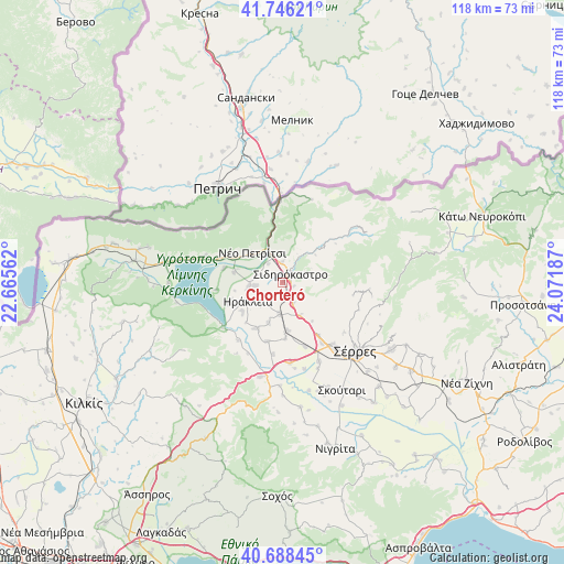
Chorteró GPS coordinates[2]
41° 13' 10.092" North, 23° 22' 7.464" East
| Map corner | latitude | longitude |
|---|---|---|
| Upper-left | 41.74621°, | 22.66562° |
| Center: | 41.21947°, | 23.36874° |
| Lower-right: | 40.68845°, | 24.07187° |
| Map W x H: | 117.6×117.6 km | = 73.1×73.1mi |
| max Lat: | 41.72048° ⇑2.1% North |
| Chorteró: | 41.21947° |
| min Lat: | ⇓97.9% South 34.8346° |
| min Long | Chorteró | max Long |
| 19.40494° | 23.36874° | 29.59361° |
| W 61.6%⇐ | ⇒38.4% E |
Elevation
Elevation of Chorteró is 58 m = 190 ft, and this is 110.9 m = 364 ft below average elevation for this country.
| Max E: |
1439 m = 4721 ft | 57.4% |
| Avg. | 168.9 m = 554 ft | |
| Chorteró | 58 m = 190 ft | |
Min E: |
0 m = 0 ft | 42.6% |
See also: Greece elevation on elevation.city.
Geographical zone
Chorteró is located in North temperate zone (between Tropic of Cancer and the Arctic Circle). Distance of this Northern Tropic circle is 1977.3 km =1228.6 mi to South.| Distance of | km | miles | from Chorteró |
|---|---|---|---|
| North Pole | 5423.9 | 3370.3 | to North |
| Arctic Circle | 2818 | 1751 | to North |
| Tropic Cancer | 1977.3 | 1228.6 | to South |
| Equator | 4583.2 | 2847.9 | to South |


Nearby cities:
15 places around Chorteró: (largest is in red/bold)
• Ammoudhiá
8.9 km =5.5 mi,  198°
198°
• Charopó
4.6 km =2.9 mi,  4°
4°
• Dasochóri
10.5 km =6.5 mi,  233°
233°
• Gefyroúdi
6.7 km =4.2 mi,  185°
185°
• Irákleia
8.3 km =5.2 mi,  240°
240°
• Koímisi
5.8 km =3.6 mi,  262°
262°
• Melenikítsi
10.2 km =6.3 mi,  141°
141°
• Néo Petrítsi
8.8 km =5.5 mi,  314°
314°
• Palaiókastro
7.9 km =4.9 mi,  152°
152°
• Pontisméno
7.2 km =4.5 mi, 260°
• Sidirókastro
2.4 km =1.5 mi,  44°
44°
• Skotoússa
10.2 km =6.3 mi,  173°
173°
• Valteró
6 km =3.7 mi,  222°
222°
• Vamvakófyto
5 km =3.1 mi, 153°
• Vyróneia
11 km =6.8 mi,  297°
297°
Sources, notices
• [Note1] Compared only with cities in Greece existing in our database
• [Src1] Map data: © OpenStreetMap contributors (CC-BY-SA)
• [Src2] Other city data from geonames.org with taken over terms of usage.
• [Src3] Geographical zone / Annual Mean Temperature by Robert A. Rohde @ Wikipedia
