Eleoúsa geodata
Eleoúsa (Central Macedonia) is a populated place; located in Greece in Europe/Athens (GMT+3) time zone. With population of 537 people, there are 1724 cities with bigger population in this country. Compared to other cities in Greece, 83% of cities are located further ↓South; 56.6% of cities are located further →East and 87.7% of cities have higher elevation than Eleoúsa. Note1
Administrative division(s):
- Level 1: Central Macedonia
- Level 2: Nomós Thessaloníkis
- Level 3: Dimos Chalkidona


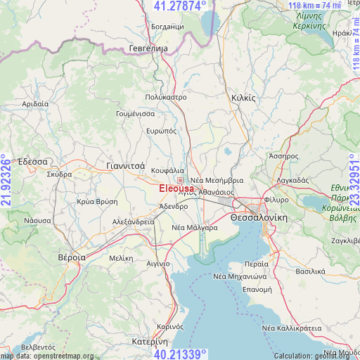
Eleoúsa GPS coordinates[2]
40° 44' 53.52" North, 22° 37' 34.968" East
| Map corner | latitude | longitude |
|---|---|---|
| Upper-left | 41.27874°, | 21.92326° |
| Center: | 40.7482°, | 22.62638° |
| Lower-right: | 40.21339°, | 23.32951° |
| Map W x H: | 118.5×118.5 km | = 73.6×73.6mi |
| max Lat: | 41.72048° ⇑17% North |
| Eleoúsa: | 40.7482° |
| min Lat: | ⇓83% South 34.8346° |
| min Long | Eleoúsa | max Long |
| 19.40494° | 22.62638° | 29.59361° |
| W 43.4%⇐ | ⇒56.6% E |
Elevation
Elevation of Eleoúsa is 10 m = 33 ft, and this is 158.9 m = 521 ft below average elevation for this country.
| Max E: |
1439 m = 4721 ft | 87.7% |
| Avg. | 168.9 m = 554 ft | |
| Eleoúsa | 10 m = 33 ft | |
Min E: |
0 m = 0 ft | 12.3% |
See also: Greece elevation on elevation.city.
Geographical zone
Eleoúsa is located in North temperate zone (between Tropic of Cancer and the Arctic Circle). Distance of this Northern Tropic circle is 1924.9 km =1196.1 mi to South.| Distance of | km | miles | from Eleoúsa |
|---|---|---|---|
| North Pole | 5476.3 | 3402.8 | to North |
| Arctic Circle | 2870.4 | 1783.6 | to North |
| Tropic Cancer | 1924.9 | 1196.1 | to South |
| Equator | 4530.8 | 2815.3 | to South |


Nearby cities:
15 places around Eleoúsa: (largest is in red/bold)
• Chalkidóna
2.9 km =1.8 mi,  230°
230°
• Géfyra
5.9 km =3.7 mi,  107°
107°
• Kastanás
8.3 km =5.2 mi,  19°
19°
• Koufália
5.6 km =3.5 mi,  305°
305°
• Mikró Monastíri
8.7 km =5.4 mi,  235°
235°
• Néo Agionéri
9.5 km =5.9 mi,  45°
45°
• Parthéni
5.6 km =3.5 mi,  197°
197°
• Próchoma
6.5 km =4 mi,  31°
31°
• Pélla
8.6 km =5.3 mi,  280°
280°
• Rachóna
10.3 km =6.4 mi, 313°
• Vathýlakkos
7.3 km =4.5 mi,  71°
71°
• Vrachiá
9.6 km =6 mi,  172°
172°
• Ádendro
8.7 km =5.4 mi,  192°
192°
• Ágios Athanásios
9.3 km =5.8 mi, 112°
• Áthyra
9.1 km =5.7 mi,  341°
341°
Sources, notices
• [Note1] Compared only with cities in Greece existing in our database
• [Src1] Map data: © OpenStreetMap contributors (CC-BY-SA)
• [Src2] Other city data from geonames.org with taken over terms of usage.
• [Src3] Geographical zone / Annual Mean Temperature by Robert A. Rohde @ Wikipedia
