Prosotsáni geodata
Prosotsáni (East Macedonia and Thrace) is a seat of a third-order administrative division; located in Greece in Europe/Athens (GMT+3) time zone. With population of 4,021 people, there are 280 cities with bigger population in this country. Compared to other cities in Greece, 97.4% of cities are located further ↓South; 77.8% of cities are located further ←West and 64.7% of cities have lower elevation than Prosotsáni. Note1
Administrative division(s):
- Level 1: East Macedonia and Thrace
- Level 2: Nomós Drámas
- Level 3: Dimos Prosotsani


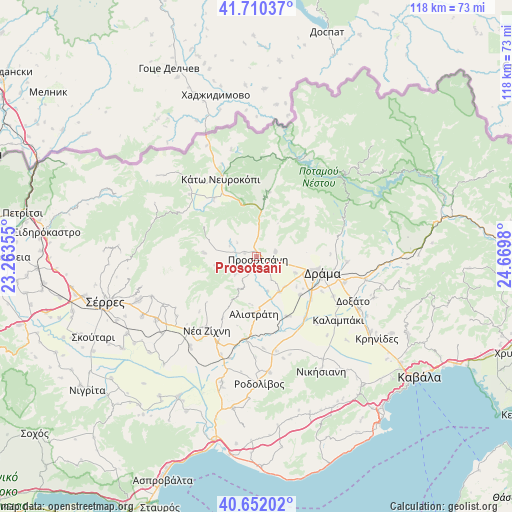
Prosotsáni GPS coordinates[2]
41° 10' 59.988" North, 23° 58' 0.012" East
| Map corner | latitude | longitude |
|---|---|---|
| Upper-left | 41.71037°, | 23.26355° |
| Center: | 41.18333°, | 23.96667° |
| Lower-right: | 40.65202°, | 24.6698° |
| Map W x H: | 117.7×117.7 km | = 73.1×73.1mi |
| max Lat: | 41.72048° ⇑2.6% North |
| Prosotsáni: | 41.18333° |
| min Lat: | ⇓97.4% South 34.8346° |
| min Long | Prosotsáni | max Long |
| 19.40494° | 23.96667° | 29.59361° |
| W 77.8%⇐ | ⇒22.2% E |
Elevation
Elevation of Prosotsáni is 139 m = 456 ft, and this is 29.9 m = 98 ft below average elevation for this country.
| Max E: |
1439 m = 4721 ft | 35.3% |
| Avg. | 168.9 m = 554 ft | |
| Prosotsáni | 139 m = 456 ft | |
Min E: |
0 m = 0 ft | 64.7% |
See also: Greece elevation on elevation.city.
Geographical zone
Prosotsáni is located in North temperate zone (between Tropic of Cancer and the Arctic Circle). Distance of this Northern Tropic circle is 1973.2 km =1226.1 mi to South.| Distance of | km | miles | from Prosotsáni |
|---|---|---|---|
| North Pole | 5427.9 | 3372.7 | to North |
| Arctic Circle | 2822 | 1753.5 | to North |
| Tropic Cancer | 1973.2 | 1226.1 | to South |
| Equator | 4579.2 | 2845.4 | to South |


Nearby cities:
15 places around Prosotsáni: (largest is in red/bold)
• Alistráti
13.2 km =8.2 mi,  183°
183°
• Choristí
21.1 km =13.1 mi,  106°
106°
• Dráma
15.5 km =9.6 mi,  102°
102°
• Fotolívos
15.3 km =9.5 mi,  153°
153°
• Kallífytos
20.8 km =12.9 mi,  93°
93°
• Kalí Vrýsi
6.5 km =4 mi,  230°
230°
• Kalós Agrós
13.2 km =8.2 mi,  130°
130°
• Krinída
21 km =13 mi, 176°
• Káto Nevrokópi
20.3 km =12.6 mi,  335°
335°
• Mikrópolis
12.7 km =7.9 mi,  275°
275°
• Néa Zíchni
20.4 km =12.7 mi,  214°
214°
• Petroússa
4.4 km =2.7 mi,  73°
73°
• Sitagroí
9.6 km =6 mi, 147°
• Vólakas
15.1 km =9.4 mi,  11°
11°
• Xiropótamos
11.5 km =7.1 mi, 85°
Sources, notices
• [Note1] Compared only with cities in Greece existing in our database
• [Src1] Map data: © OpenStreetMap contributors (CC-BY-SA)
• [Src2] Other city data from geonames.org with taken over terms of usage.
• [Src3] Geographical zone / Annual Mean Temperature by Robert A. Rohde @ Wikipedia
