Kallífytos geodata
Kallífytos (East Macedonia and Thrace) is a populated place; located in Greece in Europe/Athens (GMT+3) time zone. With population of 1,098 people, there are 920 cities with bigger population in this country. Compared to other cities in Greece, 97.1% of cities are located further ↓South; 81.4% of cities are located further ←West and 75.6% of cities have lower elevation than Kallífytos. Note1
Administrative division(s):
- Level 1: East Macedonia and Thrace
- Level 2: Nomós Drámas
- Level 3: Dimos Drama


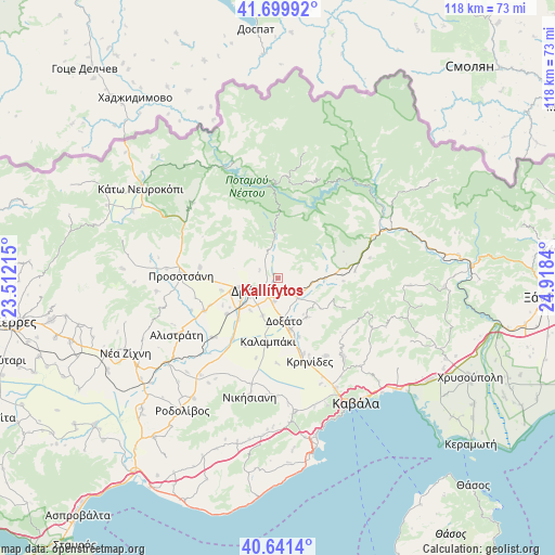
Kallífytos GPS coordinates[2]
41° 10' 22.08" North, 24° 12' 54.972" East
| Map corner | latitude | longitude |
|---|---|---|
| Upper-left | 41.69992°, | 23.51215° |
| Center: | 41.1728°, | 24.21527° |
| Lower-right: | 40.6414°, | 24.9184° |
| Map W x H: | 117.7×117.7 km | = 73.1×73.1mi |
| max Lat: | 41.72048° ⇑2.9% North |
| Kallífytos: | 41.1728° |
| min Lat: | ⇓97.1% South 34.8346° |
| min Long | Kallífytos | max Long |
| 19.40494° | 24.21527° | 29.59361° |
| W 81.4%⇐ | ⇒18.6% E |
Elevation
Elevation of Kallífytos is 217 m = 712 ft, and this is 48.1 m = 158 ft above average elevation for this country.
| Max E: |
1439 m = 4721 ft | 24.4% |
| Kallífytos | 217 m 712 ft | |
| Avg. | 168.9 m = 554 ft | |
Min E: |
0 m = 0 ft | 75.6% |
See also: Greece elevation on elevation.city.
Geographical zone
Kallífytos is located in North temperate zone (between Tropic of Cancer and the Arctic Circle). Distance of this Northern Tropic circle is 1972.1 km =1225.4 mi to South.| Distance of | km | miles | from Kallífytos |
|---|---|---|---|
| North Pole | 5429.1 | 3373.5 | to North |
| Arctic Circle | 2823.2 | 1754.3 | to North |
| Tropic Cancer | 1972.1 | 1225.4 | to South |
| Equator | 4578 | 2844.6 | to South |


Nearby cities:
15 places around Kallífytos: (largest is in red/bold)
• Choristí
4.7 km =2.9 mi,  186°
186°
• Dráma
6.1 km =3.8 mi,  248°
248°
• Fotolívos
18.8 km =11.7 mi,  228°
228°
• Fteliá
10.2 km =6.3 mi, 192°
• Fílippoi
19.4 km =12.1 mi,  147°
147°
• Kalampáki
13.9 km =8.6 mi, 191°
• Kalós Agrós
13.2 km =8.2 mi,  235°
235°
• Krinídes
18.9 km =11.7 mi,  158°
158°
• Kýria
10.3 km =6.4 mi,  142°
142°
• Lydía
16.8 km =10.4 mi, 160°
• Petroússa
16.7 km =10.4 mi,  278°
278°
• Prosotsáni
20.8 km =12.9 mi,  273°
273°
• Sitagroí
17.2 km =10.7 mi, 246°
• Xiropótamos
9.6 km =6 mi, 282°
• Ágios Athanásios
11.2 km =7 mi,  166°
166°
Sources, notices
• [Note1] Compared only with cities in Greece existing in our database
• [Src1] Map data: © OpenStreetMap contributors (CC-BY-SA)
• [Src2] Other city data from geonames.org with taken over terms of usage.
• [Src3] Geographical zone / Annual Mean Temperature by Robert A. Rohde @ Wikipedia
