Fotolívos geodata
Fotolívos (East Macedonia and Thrace) is a populated place; located in Greece in Europe/Athens (GMT+3) time zone. With population of 1,844 people, there are 559 cities with bigger population in this country. Compared to other cities in Greece, 94.1% of cities are located further ↓South; 79.7% of cities are located further ←West and 55.7% of cities have higher elevation than Fotolívos. Note1
Administrative division(s):
- Level 1: East Macedonia and Thrace
- Level 2: Nomós Drámas
- Level 3: Dimos Prosotsani


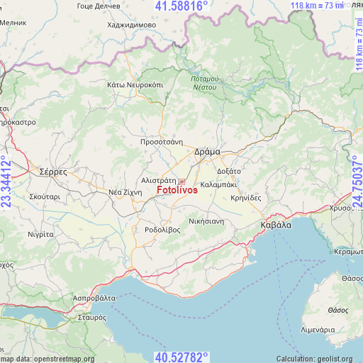
Fotolívos GPS coordinates[2]
41° 3' 36.468" North, 24° 2' 50.064" East
| Map corner | latitude | longitude |
|---|---|---|
| Upper-left | 41.58816°, | 23.34412° |
| Center: | 41.06013°, | 24.04724° |
| Lower-right: | 40.52782°, | 24.75037° |
| Map W x H: | 117.9×117.9 km | = 73.3×73.3mi |
| max Lat: | 41.72048° ⇑5.9% North |
| Fotolívos: | 41.06013° |
| min Lat: | ⇓94.1% South 34.8346° |
| min Long | Fotolívos | max Long |
| 19.40494° | 24.04724° | 29.59361° |
| W 79.7%⇐ | ⇒20.3% E |
Elevation
Elevation of Fotolívos is 63 m = 207 ft, and this is 105.9 m = 347 ft below average elevation for this country.
| Max E: |
1439 m = 4721 ft | 55.7% |
| Avg. | 168.9 m = 554 ft | |
| Fotolívos | 63 m = 207 ft | |
Min E: |
0 m = 0 ft | 44.3% |
See also: Greece elevation on elevation.city.
Geographical zone
Fotolívos is located in North temperate zone (between Tropic of Cancer and the Arctic Circle). Distance of this Northern Tropic circle is 1959.5 km =1217.6 mi to South.| Distance of | km | miles | from Fotolívos |
|---|---|---|---|
| North Pole | 5441.6 | 3381.3 | to North |
| Arctic Circle | 2835.7 | 1762 | to North |
| Tropic Cancer | 1959.5 | 1217.6 | to South |
| Equator | 4565.5 | 2836.9 | to South |


Nearby cities:
15 places around Fotolívos: (largest is in red/bold)
• Alistráti
7.5 km =4.7 mi,  273°
273°
• Dráma
13.3 km =8.3 mi,  39°
39°
• Fteliá
12.2 km =7.6 mi,  78°
78°
• Georgianí
14.3 km =8.9 mi,  143°
143°
• Kalampáki
11.5 km =7.1 mi,  95°
95°
• Kalí Vrýsi
15.2 km =9.4 mi,  309°
309°
• Kalós Agrós
6 km =3.7 mi,  32°
32°
• Kormísta
8.9 km =5.5 mi,  175°
175°
• Krinída
9 km =5.6 mi,  216°
216°
• Nikísiani
14.9 km =9.3 mi,  147°
147°
• Néa Báfra
8.3 km =5.2 mi,  195°
195°
• Petroússa
15.2 km =9.4 mi,  350°
350°
• Prosotsáni
15.3 km =9.5 mi,  333°
333°
• Próti
13.5 km =8.4 mi, 196°
• Sitagroí
5.9 km =3.7 mi,  343°
343°
Sources, notices
• [Note1] Compared only with cities in Greece existing in our database
• [Src1] Map data: © OpenStreetMap contributors (CC-BY-SA)
• [Src2] Other city data from geonames.org with taken over terms of usage.
• [Src3] Geographical zone / Annual Mean Temperature by Robert A. Rohde @ Wikipedia
