Petroússa geodata
Petroússa (East Macedonia and Thrace) is a populated place; located in Greece in Europe/Athens (GMT+3) time zone. With population of 1,985 people, there are 522 cities with bigger population in this country. Compared to other cities in Greece, 97.6% of cities are located further ↓South; 79.1% of cities are located further ←West and 78.8% of cities have lower elevation than Petroússa. Note1
Administrative division(s):
- Level 1: East Macedonia and Thrace
- Level 2: Nomós Drámas
- Level 3: Dimos Prosotsani


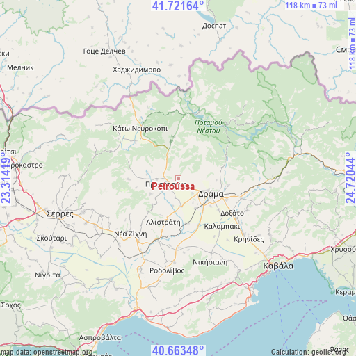
Petroússa GPS coordinates[2]
41° 11' 40.92" North, 24° 1' 2.316" East
| Map corner | latitude | longitude |
|---|---|---|
| Upper-left | 41.72164°, | 23.31419° |
| Center: | 41.1947°, | 24.01731° |
| Lower-right: | 40.66348°, | 24.72044° |
| Map W x H: | 117.7×117.7 km | = 73.1×73.1mi |
| max Lat: | 41.72048° ⇑2.4% North |
| Petroússa: | 41.1947° |
| min Lat: | ⇓97.6% South 34.8346° |
| min Long | Petroússa | max Long |
| 19.40494° | 24.01731° | 29.59361° |
| W 79.1%⇐ | ⇒20.9% E |
Elevation
Elevation of Petroússa is 262 m = 860 ft, and this is 93.1 m = 305 ft above average elevation for this country.
| Max E: |
1439 m = 4721 ft | 21.2% |
| Petroússa | 262 m 860 ft | |
| Avg. | 168.9 m = 554 ft | |
Min E: |
0 m = 0 ft | 78.8% |
See also: Greece elevation on elevation.city.
Geographical zone
Petroússa is located in North temperate zone (between Tropic of Cancer and the Arctic Circle). Distance of this Northern Tropic circle is 1974.5 km =1226.9 mi to South.| Distance of | km | miles | from Petroússa |
|---|---|---|---|
| North Pole | 5426.6 | 3371.9 | to North |
| Arctic Circle | 2820.8 | 1752.8 | to North |
| Tropic Cancer | 1974.5 | 1226.9 | to South |
| Equator | 4580.4 | 2846.1 | to South |


Nearby cities:
15 places around Petroússa: (largest is in red/bold)
• Alistráti
15.3 km =9.5 mi,  199°
199°
• Choristí
17.5 km =10.9 mi,  114°
114°
• Dráma
11.8 km =7.3 mi, 113°
• Fotolívos
15.2 km =9.4 mi,  170°
170°
• Fteliá
19.1 km =11.9 mi,  130°
130°
• Kalampáki
21.3 km =13.2 mi,  139°
139°
• Kallífytos
16.7 km =10.4 mi,  98°
98°
• Kalí Vrýsi
10.7 km =6.6 mi,  239°
239°
• Kalós Agrós
11.5 km =7.1 mi,  150°
150°
• Káto Nevrokópi
21.4 km =13.3 mi,  323°
323°
• Mikrópolis
16.9 km =10.5 mi,  269°
269°
• Prosotsáni
4.4 km =2.7 mi,  253°
253°
• Sitagroí
9.4 km =5.8 mi, 174°
• Vólakas
13.6 km =8.5 mi,  354°
354°
• Xiropótamos
7.2 km =4.5 mi,  92°
92°
Sources, notices
• [Note1] Compared only with cities in Greece existing in our database
• [Src1] Map data: © OpenStreetMap contributors (CC-BY-SA)
• [Src2] Other city data from geonames.org with taken over terms of usage.
• [Src3] Geographical zone / Annual Mean Temperature by Robert A. Rohde @ Wikipedia
