Kalós Agrós geodata
Kalós Agrós (East Macedonia and Thrace) is a populated place; located in Greece in Europe/Athens (GMT+3) time zone. With population of 1,275 people, there are 791 cities with bigger population in this country. Compared to other cities in Greece, 95.6% of cities are located further ↓South; 80% of cities are located further ←West and 54.3% of cities have higher elevation than Kalós Agrós. Note1
Administrative division(s):
- Level 1: East Macedonia and Thrace
- Level 2: Nomós Drámas
- Level 3: Dimos Drama


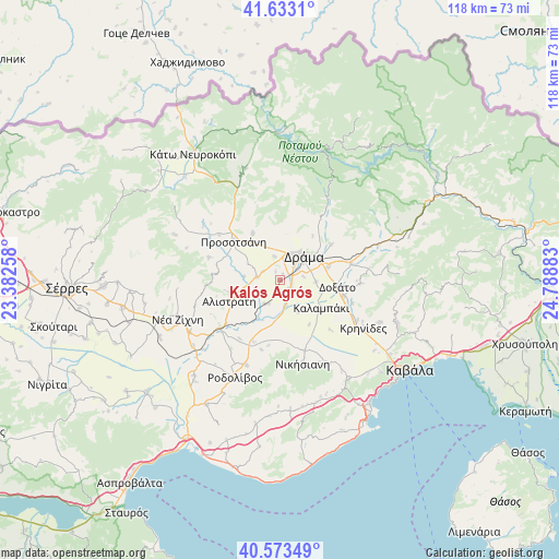
Kalós Agrós GPS coordinates[2]
41° 6' 19.548" North, 24° 5' 8.52" East
| Map corner | latitude | longitude |
|---|---|---|
| Upper-left | 41.6331°, | 23.38258° |
| Center: | 41.10543°, | 24.0857° |
| Lower-right: | 40.57349°, | 24.78883° |
| Map W x H: | 117.8×117.8 km | = 73.2×73.2mi |
| max Lat: | 41.72048° ⇑4.4% North |
| Kalós Agrós: | 41.10543° |
| min Lat: | ⇓95.6% South 34.8346° |
| min Long | Kalós Agrós | max Long |
| 19.40494° | 24.0857° | 29.59361° |
| W 80%⇐ | ⇒20% E |
Elevation
Elevation of Kalós Agrós is 67 m = 220 ft, and this is 101.9 m = 334 ft below average elevation for this country.
| Max E: |
1439 m = 4721 ft | 54.3% |
| Avg. | 168.9 m = 554 ft | |
| Kalós Agrós | 67 m = 220 ft | |
Min E: |
0 m = 0 ft | 45.7% |
See also: Greece elevation on elevation.city.
Geographical zone
Kalós Agrós is located in North temperate zone (between Tropic of Cancer and the Arctic Circle). Distance of this Northern Tropic circle is 1964.6 km =1220.7 mi to South.| Distance of | km | miles | from Kalós Agrós |
|---|---|---|---|
| North Pole | 5436.6 | 3378.1 | to North |
| Arctic Circle | 2830.7 | 1758.9 | to North |
| Tropic Cancer | 1964.6 | 1220.7 | to South |
| Equator | 4570.5 | 2840 | to South |


Nearby cities:
15 places around Kalós Agrós: (largest is in red/bold)
• Alistráti
11.7 km =7.3 mi,  247°
247°
• Choristí
10.7 km =6.6 mi,  74°
74°
• Dráma
7.4 km =4.6 mi,  44°
44°
• Fotolívos
6 km =3.7 mi,  212°
212°
• Fteliá
9.1 km =5.7 mi,  106°
106°
• Kalampáki
10.2 km =6.3 mi,  126°
126°
• Kallífytos
13.2 km =8.2 mi,  55°
55°
• Kormísta
14.2 km =8.8 mi,  190°
190°
• Krinída
15 km =9.3 mi, 214°
• Néa Báfra
14.1 km =8.8 mi,  202°
202°
• Petroússa
11.5 km =7.1 mi,  330°
330°
• Prosotsáni
13.2 km =8.2 mi,  310°
310°
• Sitagroí
4.9 km =3 mi,  276°
276°
• Xiropótamos
9.8 km =6.1 mi,  8°
8°
• Ágios Athanásios
13.8 km =8.6 mi,  104°
104°
Sources, notices
• [Note1] Compared only with cities in Greece existing in our database
• [Src1] Map data: © OpenStreetMap contributors (CC-BY-SA)
• [Src2] Other city data from geonames.org with taken over terms of usage.
• [Src3] Geographical zone / Annual Mean Temperature by Robert A. Rohde @ Wikipedia
