Dráma geodata
Dráma (East Macedonia and Thrace) is a seat of a second-order administrative division; located in Greece in Europe/Athens (GMT+3) time zone. With population of 44,823 people, there are 47 cities with bigger population in this country. Compared to other cities in Greece, 96.9% of cities are located further ↓South; 80.6% of cities are located further ←West and 61.1% of cities have lower elevation than Dráma. Note1
Administrative division(s):
- Level 1: East Macedonia and Thrace
- Level 2: Nomós Drámas
- Level 3: Dimos Drama


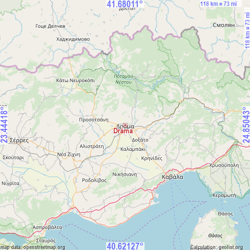
Dráma GPS coordinates[2]
41° 9' 10.188" North, 24° 8' 50.28" East
| Map corner | latitude | longitude |
|---|---|---|
| Upper-left | 41.68011°, | 23.44418° |
| Center: | 41.15283°, | 24.1473° |
| Lower-right: | 40.62127°, | 24.85043° |
| Map W x H: | 117.7×117.7 km | = 73.1×73.1mi |
| max Lat: | 41.72048° ⇑3.1% North |
| Dráma: | 41.15283° |
| min Lat: | ⇓96.9% South 34.8346° |
| min Long | Dráma | max Long |
| 19.40494° | 24.1473° | 29.59361° |
| W 80.6%⇐ | ⇒19.4% E |
Elevation
Elevation of Dráma is 122 m = 400 ft, and this is 46.9 m = 154 ft below average elevation for this country.
| Max E: |
1439 m = 4721 ft | 38.9% |
| Avg. | 168.9 m = 554 ft | |
| Dráma | 122 m = 400 ft | |
Min E: |
0 m = 0 ft | 61.1% |
See also: Dráma elevation on elevation.city.
Geographical zone
Dráma is located in North temperate zone (between Tropic of Cancer and the Arctic Circle). Distance of this Northern Tropic circle is 1969.8 km =1224 mi to South.| Distance of | km | miles | from Dráma |
|---|---|---|---|
| North Pole | 5431.3 | 3374.9 | to North |
| Arctic Circle | 2825.4 | 1755.6 | to North |
| Tropic Cancer | 1969.8 | 1224 | to South |
| Equator | 4575.8 | 2843.3 | to South |


Nearby cities:
15 places around Dráma: (largest is in red/bold)
• Alistráti
18.7 km =11.6 mi,  238°
238°
• Choristí
5.7 km =3.5 mi,  115°
115°
• Fotolívos
13.3 km =8.3 mi,  219°
219°
• Fteliá
8.6 km =5.3 mi,  155°
155°
• Kalampáki
11.8 km =7.3 mi,  165°
165°
• Kallífytos
6.1 km =3.8 mi,  68°
68°
• Kalós Agrós
7.4 km =4.6 mi, 224°
• Krinídes
19.9 km =12.4 mi,  141°
141°
• Kýria
13.3 km =8.3 mi, 116°
• Lydía
17.6 km =10.9 mi, 140°
• Petroússa
11.8 km =7.3 mi,  293°
293°
• Prosotsáni
15.5 km =9.6 mi,  282°
282°
• Sitagroí
11.1 km =6.9 mi, 244°
• Xiropótamos
5.7 km =3.5 mi,  320°
320°
• Ágios Athanásios
12 km =7.5 mi, 136°
Sources, notices
• [Note1] Compared only with cities in Greece existing in our database
• [Src1] Map data: © OpenStreetMap contributors (CC-BY-SA)
• [Src2] Other city data from geonames.org with taken over terms of usage.
• [Src3] Geographical zone / Annual Mean Temperature by Robert A. Rohde @ Wikipedia
