Vólakas geodata
Vólakas (East Macedonia and Thrace) is a populated place; located in Greece in Europe/Athens (GMT+3) time zone. With population of 1,225 people, there are 811 cities with bigger population in this country. Compared to other cities in Greece, 99% of cities are located further ↓South; 78.7% of cities are located further ←West and 97.9% of cities have lower elevation than Vólakas. Note1
Administrative division(s):
- Level 1: East Macedonia and Thrace
- Level 2: Nomós Drámas
- Level 3: Dimos Kato Nevrokopi


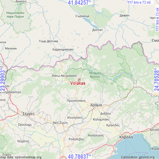
Vólakas GPS coordinates[2]
41° 18' 59.796" North, 24° 0' 7.74" East
| Map corner | latitude | longitude |
|---|---|---|
| Upper-left | 41.84257°, | 23.29903° |
| Center: | 41.31661°, | 24.00215° |
| Lower-right: | 40.78637°, | 24.70528° |
| Map W x H: | 117.4×117.4 km | = 72.9×72.9mi |
| max Lat: | 41.72048° ⇑1% North |
| Vólakas: | 41.31661° |
| min Lat: | ⇓99% South 34.8346° |
| min Long | Vólakas | max Long |
| 19.40494° | 24.00215° | 29.59361° |
| W 78.7%⇐ | ⇒21.3% E |
Elevation
Elevation of Vólakas is 832 m = 2730 ft, and this is 663.1 m = 2176 ft above average elevation for this country.
| Max E: |
1439 m = 4721 ft | 2.1% |
| Vólakas | 832 m 2730 ft | |
| Avg. | 168.9 m = 554 ft | |
Min E: |
0 m = 0 ft | 97.9% |
See also: Greece elevation on elevation.city.
Geographical zone
Vólakas is located in North temperate zone (between Tropic of Cancer and the Arctic Circle). Distance of this Northern Tropic circle is 1988.1 km =1235.3 mi to South.| Distance of | km | miles | from Vólakas |
|---|---|---|---|
| North Pole | 5413.1 | 3363.5 | to North |
| Arctic Circle | 2807.2 | 1744.3 | to North |
| Tropic Cancer | 1988.1 | 1235.3 | to South |
| Equator | 4594 | 2854.6 | to South |


Nearby cities:
15 places around Vólakas: (largest is in red/bold)
• Alistráti
28.3 km =17.6 mi,  187°
187°
• Choristí
26.9 km =16.7 mi,  140°
140°
• Dráma
21.9 km =13.6 mi,  146°
146°
• Fotolívos
28.8 km =17.9 mi,  172°
172°
• Fteliá
30.4 km =18.9 mi, 148°
• Kalampáki
33.3 km =20.7 mi, 152°
• Kallífytos
23.9 km =14.9 mi,  131°
131°
• Kalí Vrýsi
20.5 km =12.7 mi,  202°
202°
• Kalós Agrós
24.5 km =15.2 mi,  163°
163°
• Káto Nevrokópi
11.9 km =7.4 mi,  288°
288°
• Mikrópolis
20.7 km =12.9 mi,  228°
228°
• Petroússa
13.6 km =8.5 mi, 174°
• Prosotsáni
15.1 km =9.4 mi, 191°
• Sitagroí
23 km =14.3 mi, 174°
• Xiropótamos
16.2 km =10.1 mi, 148°
Sources, notices
• [Note1] Compared only with cities in Greece existing in our database
• [Src1] Map data: © OpenStreetMap contributors (CC-BY-SA)
• [Src2] Other city data from geonames.org with taken over terms of usage.
• [Src3] Geographical zone / Annual Mean Temperature by Robert A. Rohde @ Wikipedia
