Erátyra geodata
Erátyra (West Macedonia) is a populated place; located in Greece in Europe/Athens (GMT+3) time zone. With population of 1,383 people, there are 731 cities with bigger population in this country. Compared to other cities in Greece, 71.1% of cities are located further ↓South; 82.6% of cities are located further →East and 96.9% of cities have lower elevation than Erátyra. Note1


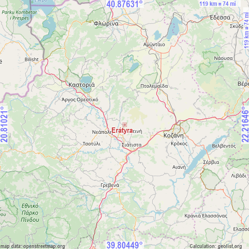
Erátyra GPS coordinates[2]
40° 20' 33.108" North, 21° 30' 47.988" East
| Map corner | latitude | longitude |
|---|---|---|
| Upper-left | 40.87631°, | 20.81021° |
| Center: | 40.34253°, | 21.51333° |
| Lower-right: | 39.80449°, | 22.21646° |
| Map W x H: | 119.2×119.2 km | = 74.1×74.1mi |
| max Lat: | 41.72048° ⇑28.9% North |
| Erátyra: | 40.34253° |
| min Lat: | ⇓71.1% South 34.8346° |
| min Long | Erátyra | max Long |
| 19.40494° | 21.51333° | 29.59361° |
| W 17.4%⇐ | ⇒82.6% E |
Elevation
Elevation of Erátyra is 767 m = 2516 ft, and this is 598.1 m = 1962 ft above average elevation for this country.
| Max E: |
1439 m = 4721 ft | 3.1% |
| Erátyra | 767 m 2516 ft | |
| Avg. | 168.9 m = 554 ft | |
Min E: |
0 m = 0 ft | 96.9% |
See also: Greece elevation on elevation.city.
Geographical zone
Erátyra is located in North temperate zone (between Tropic of Cancer and the Arctic Circle). Distance of this Northern Tropic circle is 1879.7 km =1168 mi to South.| Distance of | km | miles | from Erátyra |
|---|---|---|---|
| North Pole | 5521.4 | 3430.8 | to North |
| Arctic Circle | 2915.5 | 1811.6 | to North |
| Tropic Cancer | 1879.7 | 1168 | to South |
| Equator | 4485.7 | 2787.3 | to South |


Nearby cities:
15 places around Erátyra: (largest is in red/bold)
• Ampelókipoi
22 km =13.7 mi,  308°
308°
• Anaráchi
17.4 km =10.8 mi,  16°
16°
• Empório
16.7 km =10.4 mi,  13°
13°
• Galatiní
4.1 km =2.5 mi,  128°
128°
• Gérmas
14.4 km =8.9 mi,  330°
330°
• Korisós
21.4 km =13.3 mi, 327°
• Kozáni
23.8 km =14.8 mi,  101°
101°
• Koíla
23.6 km =14.7 mi,  93°
93°
• Néo Kostarázi
18.5 km =11.5 mi,  303°
303°
• Ptolemaḯda
23.7 km =14.7 mi,  36°
36°
• Siátista
9.3 km =5.8 mi,  163°
163°
• Tsotíli
18.3 km =11.4 mi,  240°
240°
• Varikó
21.9 km =13.6 mi,  357°
357°
• Vogatsikó
13.8 km =8.6 mi, 305°
• Árdassa
18.1 km =11.2 mi,  34°
34°
Sources, notices
• [Note1] Compared only with cities in Greece existing in our database
• [Src1] Map data: © OpenStreetMap contributors (CC-BY-SA)
• [Src2] Other city data from geonames.org with taken over terms of usage.
• [Src3] Geographical zone / Annual Mean Temperature by Robert A. Rohde @ Wikipedia
