Koíla geodata
Koíla (West Macedonia) is a populated place; located in Greece in Europe/Athens (GMT+3) time zone. With population of 1,493 people, there are 666 cities with bigger population in this country. Compared to other cities in Greece, 70.9% of cities are located further ↓South; 76.6% of cities are located further →East and 95.1% of cities have lower elevation than Koíla. Note1


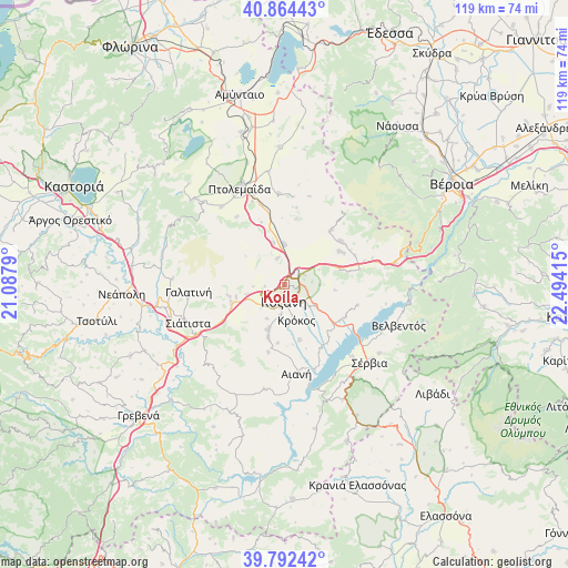
Koíla GPS coordinates[2]
40° 19' 49.98" North, 21° 47' 27.672" East
| Map corner | latitude | longitude |
|---|---|---|
| Upper-left | 40.86443°, | 21.0879° |
| Center: | 40.33055°, | 21.79102° |
| Lower-right: | 39.79242°, | 22.49415° |
| Map W x H: | 119.2×119.2 km | = 74.1×74.1mi |
| max Lat: | 41.72048° ⇑29.1% North |
| Koíla: | 40.33055° |
| min Lat: | ⇓70.9% South 34.8346° |
| min Long | Koíla | max Long |
| 19.40494° | 21.79102° | 29.59361° |
| W 23.4%⇐ | ⇒76.6% E |
Elevation
Elevation of Koíla is 671 m = 2201 ft, and this is 502.1 m = 1647 ft above average elevation for this country.
| Max E: |
1439 m = 4721 ft | 4.9% |
| Koíla | 671 m 2201 ft | |
| Avg. | 168.9 m = 554 ft | |
Min E: |
0 m = 0 ft | 95.1% |
See also: Greece elevation on elevation.city.
Geographical zone
Koíla is located in North temperate zone (between Tropic of Cancer and the Arctic Circle). Distance of this Northern Tropic circle is 1878.4 km =1167.2 mi to South.| Distance of | km | miles | from Koíla |
|---|---|---|---|
| North Pole | 5522.7 | 3431.6 | to North |
| Arctic Circle | 2916.8 | 1812.4 | to North |
| Tropic Cancer | 1878.4 | 1167.2 | to South |
| Equator | 4484.3 | 2786.4 | to South |


Nearby cities:
15 places around Koíla: (largest is in red/bold)
• Aianí
18.7 km =11.6 mi,  172°
172°
• Akriní
15.2 km =9.4 mi,  40°
40°
• Anatolikó
24.1 km =15 mi,  351°
351°
• Erátyra
23.6 km =14.7 mi,  273°
273°
• Galatiní
20.3 km =12.6 mi, 266°
• Kleítos
12.6 km =7.8 mi,  26°
26°
• Kozáni
3.3 km =2.1 mi,  183°
183°
• Krókos
7.8 km =4.8 mi,  163°
163°
• Platanórevma
24.5 km =15.2 mi,  126°
126°
• Polýmylos
23.8 km =14.8 mi,  79°
79°
• Ptolemaḯda
22.6 km =14 mi,  335°
335°
• Siátista
22.3 km =13.9 mi,  249°
249°
• Sérvia
24.1 km =15 mi, 134°
• Áno Kómi
12 km =7.5 mi, 164°
• Árdassa
21.1 km =13.1 mi,  320°
320°
Sources, notices
• [Note1] Compared only with cities in Greece existing in our database
• [Src1] Map data: © OpenStreetMap contributors (CC-BY-SA)
• [Src2] Other city data from geonames.org with taken over terms of usage.
• [Src3] Geographical zone / Annual Mean Temperature by Robert A. Rohde @ Wikipedia
