Zunil geodata
Zunil (Quetzaltenango) is a seat of a second-order administrative division; located in Guatemala in America/Guatemala (GMT-6) time zone. With population of 9,986 people, there are 128 cities with bigger population in this country. Compared to other cities in Guatemala, 51.3% of cities are located further ↑North; 72.3% of cities are located further →East and 83.5% of cities have lower elevation than Zunil. Note1


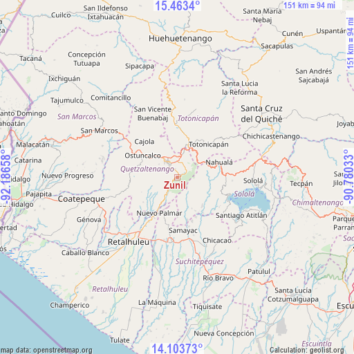
Zunil GPS coordinates[2]
14° 47' 4.668" North, 91° 29' 0.42" West
| Map corner | latitude | longitude |
|---|---|---|
| Upper-left | 15.4634°, | -92.18658° |
| Center: | 14.78463°, | -91.48345° |
| Lower-right: | 14.10373°, | -90.78033° |
| Map W x H: | 151.2×151.2 km | = 94×94mi |
| max Lat: | 17.06606° ⇑51.3% North |
| Zunil: | 14.78463° |
| min Lat: | ⇓48.7% South 13.9274° |
| min Long | Zunil | max Long |
| -92.19298° | -91.48345° | -88.59444° |
| W 27.7%⇐ | ⇒72.3% E |
Elevation
Elevation of Zunil is 2200 m = 7218 ft, and this is 933 m = 3061 ft above average elevation for this country.
| Max E: |
3254 m = 10676 ft | 16.5% |
| Zunil | 2200 m 7218 ft | |
| Avg. | 1267 m = 4157 ft | |
Min E: |
1 m = 3 ft | 83.5% |
See also: Guatemala elevation on elevation.city.
Geographical zone
Zunil is located in North Torrid zone (between Equator and Tropic of Cancer). Distance of this Northern Tropic circle is 962 km =597.8 mi to North.| Distance of | km | miles | from Zunil |
|---|---|---|---|
| North Pole | 8363.2 | 5196.6 | to North |
| Arctic Circle | 5757.3 | 3577.4 | to North |
| Tropic Cancer | 962 | 597.8 | to North |
| Equator | 1643.9 | 1021.5 | to South |


Nearby cities:
15 places around Zunil: (largest is in red/bold)
• Almolonga
3.7 km =2.3 mi,  340°
340°
• Cantel
4.3 km =2.7 mi,  45°
45°
• Concepción Chiquirichapa
17 km =10.6 mi,  297°
297°
• La Esperanza
12.8 km =8 mi,  319°
319°
• Olintepeque
11.8 km =7.3 mi, 343°
• Ostuncalco
17.5 km =10.9 mi, 302°
• Pueblo Nuevo
16.4 km =10.2 mi,  201°
201°
• Quetzaltenango
6.7 km =4.2 mi,  326°
326°
• Salcajá
10.9 km =6.8 mi,  15°
15°
• San Andrés Xecul
13.4 km =8.3 mi,  0°
0°
• San Cristóbal Totonicapán
15.4 km =9.6 mi, 17°
• San Francisco la Unión
16.7 km =10.4 mi, 337°
• San Martín Sacatepéquez
17.6 km =10.9 mi,  284°
284°
• San Mateo
14.1 km =8.8 mi,  305°
305°
• Santa Catarina Ixtahuacán
13.5 km =8.4 mi,  83°
83°
Sources, notices
• [Note1] Compared only with cities in Guatemala existing in our database
• [Src1] Map data: © OpenStreetMap contributors (CC-BY-SA)
• [Src2] Other city data from geonames.org with taken over terms of usage.
• [Src3] Geographical zone / Annual Mean Temperature by Robert A. Rohde @ Wikipedia
