Olintepeque geodata
Olintepeque (Quetzaltenango) is a seat of a second-order administrative division; located in Guatemala in America/Guatemala (GMT-6) time zone. In our database, there are 325 cities with bigger population. Compared to other cities in Guatemala, 56% of cities are located further ↓South; 74.3% of cities are located further →East and 88.8% of cities have lower elevation than Olintepeque. Note1


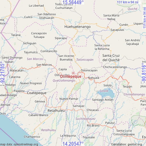
Olintepeque GPS coordinates[2]
14° 53' 9.78" North, 91° 30' 52.992" West
| Map corner | latitude | longitude |
|---|---|---|
| Upper-left | 15.56449°, | -92.21785° |
| Center: | 14.88605°, | -91.51472° |
| Lower-right: | 14.20547°, | -90.8116° |
| Map W x H: | 151.1×151.1 km | = 93.9×93.9mi |
| max Lat: | 17.06606° ⇑44% North |
| Olintepeque: | 14.88605° |
| min Lat: | ⇓56% South 13.9274° |
| min Long | Olintepeque | max Long |
| -92.19298° | -91.51472° | -88.59444° |
| W 25.7%⇐ | ⇒74.3% E |
Elevation
Elevation of Olintepeque is 2384 m = 7822 ft, and this is 1117 m = 3665 ft above average elevation for this country.
| Max E: |
3254 m = 10676 ft | 11.2% |
| Olintepeque | 2384 m 7822 ft | |
| Avg. | 1267 m = 4157 ft | |
Min E: |
1 m = 3 ft | 88.8% |
See also: Guatemala elevation on elevation.city.
Geographical zone
Olintepeque is located in North Torrid zone (between Equator and Tropic of Cancer). Distance of this Northern Tropic circle is 950.7 km =590.7 mi to North.| Distance of | km | miles | from Olintepeque |
|---|---|---|---|
| North Pole | 8351.9 | 5189.6 | to North |
| Arctic Circle | 5746 | 3570.4 | to North |
| Tropic Cancer | 950.7 | 590.7 | to North |
| Equator | 1655.2 | 1028.5 | to South |


Nearby cities:
15 places around Olintepeque: (largest is in red/bold)
• Almolonga
8.1 km =5 mi,  164°
164°
• Cajolá
11.5 km =7.1 mi,  290°
290°
• Cantel
10.5 km =6.5 mi,  142°
142°
• La Esperanza
5.3 km =3.3 mi,  252°
252°
• Ostuncalco
11.6 km =7.2 mi,  260°
260°
• Quetzaltenango
5.7 km =3.5 mi,  183°
183°
• Salcajá
6.2 km =3.9 mi,  96°
96°
• San Andrés Xecul
4 km =2.5 mi,  58°
58°
• San Carlos Sija
11.5 km =7.1 mi,  341°
341°
• San Cristóbal Totonicapán
8.7 km =5.4 mi,  66°
66°
• San Francisco El Alto
10.1 km =6.3 mi,  49°
49°
• San Francisco la Unión
5.1 km =3.2 mi,  325°
325°
• San Mateo
8.7 km =5.4 mi, 248°
• San Miguel Sigüilá
10.8 km =6.7 mi,  275°
275°
• Zunil
11.8 km =7.3 mi, 163°
Sources, notices
• [Note1] Compared only with cities in Guatemala existing in our database
• [Src1] Map data: © OpenStreetMap contributors (CC-BY-SA)
• [Src2] Other city data from geonames.org with taken over terms of usage.
• [Src3] Geographical zone / Annual Mean Temperature by Robert A. Rohde @ Wikipedia
