Cantel geodata
Cantel (Quetzaltenango) is a seat of a second-order administrative division; located in Guatemala in America/Guatemala (GMT-6) time zone. With population of 26,063 people, there are 42 cities with bigger population in this country. Compared to other cities in Guatemala, 50.7% of cities are located further ↓South; 69% of cities are located further →East and 85.8% of cities have lower elevation than Cantel. Note1


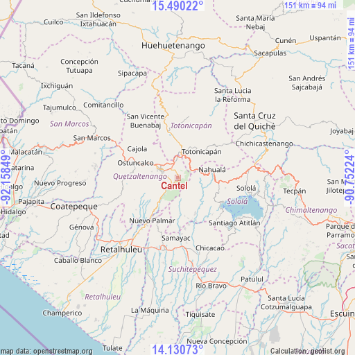
Cantel GPS coordinates[2]
14° 48' 41.544" North, 91° 27' 19.296" West
| Map corner | latitude | longitude |
|---|---|---|
| Upper-left | 15.49022°, | -92.15849° |
| Center: | 14.81154°, | -91.45536° |
| Lower-right: | 14.13073°, | -90.75224° |
| Map W x H: | 151.2×151.2 km | = 94×94mi |
| max Lat: | 17.06606° ⇑49.3% North |
| Cantel: | 14.81154° |
| min Lat: | ⇓50.7% South 13.9274° |
| min Long | Cantel | max Long |
| -92.19298° | -91.45536° | -88.59444° |
| W 31%⇐ | ⇒69% E |
Elevation
Elevation of Cantel is 2296 m = 7533 ft, and this is 1029 m = 3376 ft above average elevation for this country.
| Max E: |
3254 m = 10676 ft | 14.2% |
| Cantel | 2296 m 7533 ft | |
| Avg. | 1267 m = 4157 ft | |
Min E: |
1 m = 3 ft | 85.8% |
See also: Guatemala elevation on elevation.city.
Geographical zone
Cantel is located in North Torrid zone (between Equator and Tropic of Cancer). Distance of this Northern Tropic circle is 959 km =595.9 mi to North.| Distance of | km | miles | from Cantel |
|---|---|---|---|
| North Pole | 8360.2 | 5194.8 | to North |
| Arctic Circle | 5754.3 | 3575.6 | to North |
| Tropic Cancer | 959 | 595.9 | to North |
| Equator | 1646.9 | 1023.3 | to South |


Nearby cities:
15 places around Cantel: (largest is in red/bold)
• Almolonga
4.3 km =2.7 mi,  276°
276°
• Concepción Chiquirichapa
18.7 km =11.6 mi, 284°
• La Esperanza
13.2 km =8.2 mi,  300°
300°
• Nahualá
15.2 km =9.4 mi,  76°
76°
• Olintepeque
10.5 km =6.5 mi,  322°
322°
• Quetzaltenango
7.2 km =4.5 mi,  290°
290°
• Salcajá
7.6 km =4.7 mi,  358°
358°
• San Andrés Xecul
10.8 km =6.7 mi,  343°
343°
• San Cristóbal Totonicapán
11.8 km =7.3 mi,  7°
7°
• San Francisco El Alto
14.9 km =9.3 mi, 5°
• San Francisco la Unión
15.5 km =9.6 mi, 323°
• San Mateo
15.4 km =9.6 mi, 289°
• Santa Catarina Ixtahuacán
10.5 km =6.5 mi,  98°
98°
• Totonicapán
15.1 km =9.4 mi,  42°
42°
• Zunil
4.3 km =2.7 mi,  225°
225°
Sources, notices
• [Note1] Compared only with cities in Guatemala existing in our database
• [Src1] Map data: © OpenStreetMap contributors (CC-BY-SA)
• [Src2] Other city data from geonames.org with taken over terms of usage.
• [Src3] Geographical zone / Annual Mean Temperature by Robert A. Rohde @ Wikipedia
