San Mateo geodata
San Mateo (Quetzaltenango) is a seat of a second-order administrative division; located in Guatemala in America/Guatemala (GMT-6) time zone. With population of 5,534 people, there are 196 cities with bigger population in this country. Compared to other cities in Guatemala, 54.3% of cities are located further ↓South; 78.2% of cities are located further →East and 95% of cities have lower elevation than San Mateo. Note1


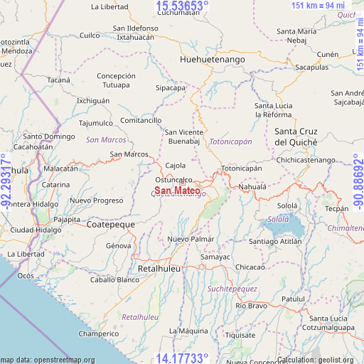
San Mateo GPS coordinates[2]
14° 51' 28.8" North, 91° 35' 24.144" West
| Map corner | latitude | longitude |
|---|---|---|
| Upper-left | 15.53653°, | -92.29317° |
| Center: | 14.858°, | -91.59004° |
| Lower-right: | 14.17733°, | -90.88692° |
| Map W x H: | 151.1×151.1 km | = 93.9×93.9mi |
| max Lat: | 17.06606° ⇑45.7% North |
| San Mateo: | 14.858° |
| min Lat: | ⇓54.3% South 13.9274° |
| min Long | San Mateo | max Long |
| -92.19298° | -91.59004° | -88.59444° |
| W 21.8%⇐ | ⇒78.2% E |
Elevation
Elevation of San Mateo is 2576 m = 8451 ft, and this is 1309 m = 4295 ft above average elevation for this country.
| Max E: |
3254 m = 10676 ft | 5% |
| San Mateo | 2576 m 8451 ft | |
| Avg. | 1267 m = 4157 ft | |
Min E: |
1 m = 3 ft | 95% |
See also: Guatemala elevation on elevation.city.
Geographical zone
San Mateo is located in North Torrid zone (between Equator and Tropic of Cancer). Distance of this Northern Tropic circle is 953.9 km =592.7 mi to North.| Distance of | km | miles | from San Mateo |
|---|---|---|---|
| North Pole | 8355 | 5191.6 | to North |
| Arctic Circle | 5749.1 | 3572.3 | to North |
| Tropic Cancer | 953.9 | 592.7 | to North |
| Equator | 1652.1 | 1026.6 | to South |


Nearby cities:
15 places around San Mateo: (largest is in red/bold)
• Almolonga
11.3 km =7 mi,  114°
114°
• Cajolá
7.6 km =4.7 mi,  339°
339°
• Concepción Chiquirichapa
3.6 km =2.2 mi,  264°
264°
• La Esperanza
3.4 km =2.1 mi,  63°
63°
• Olintepeque
8.7 km =5.4 mi,  68°
68°
• Ostuncalco
3.6 km =2.2 mi,  289°
289°
• Palestina de los Altos
14 km =8.7 mi,  306°
306°
• Quetzaltenango
8.2 km =5.1 mi, 108°
• Salcajá
14.5 km =9 mi,  80°
80°
• San Andrés Xecul
12.6 km =7.8 mi, 65°
• San Francisco la Unión
9 km =5.6 mi,  35°
35°
• San Juan Ostuncalco
10.8 km =6.7 mi,  279°
279°
• San Martín Sacatepéquez
6.7 km =4.2 mi,  236°
236°
• San Miguel Sigüilá
4.9 km =3 mi,  327°
327°
• Zunil
14.1 km =8.8 mi,  125°
125°
Sources, notices
• [Note1] Compared only with cities in Guatemala existing in our database
• [Src1] Map data: © OpenStreetMap contributors (CC-BY-SA)
• [Src2] Other city data from geonames.org with taken over terms of usage.
• [Src3] Geographical zone / Annual Mean Temperature by Robert A. Rohde @ Wikipedia
