Yepocapa geodata
Yepocapa (Chimaltenango) is a seat of a second-order administrative division; located in Guatemala in America/Guatemala (GMT-6) time zone. With population of 8,961 people, there are 143 cities with bigger population in this country. Compared to other cities in Guatemala, 82% of cities are located further ↑North; 50.4% of cities are located further →East and 55.5% of cities have lower elevation than Yepocapa. Note1


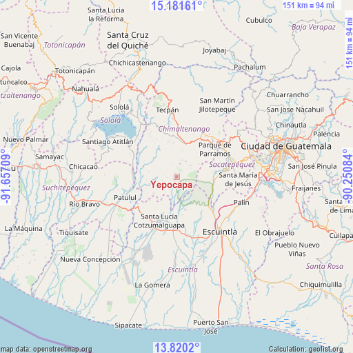
Yepocapa GPS coordinates[2]
14° 30' 7.02" North, 90° 57' 14.256" West
| Map corner | latitude | longitude |
|---|---|---|
| Upper-left | 15.18161°, | -91.65709° |
| Center: | 14.50195°, | -90.95396° |
| Lower-right: | 13.8202°, | -90.25084° |
| Map W x H: | 151.4×151.4 km | = 94.1×94.1mi |
| max Lat: | 17.06606° ⇑82% North |
| Yepocapa: | 14.50195° |
| min Lat: | ⇓18% South 13.9274° |
| min Long | Yepocapa | max Long |
| -92.19298° | -90.95396° | -88.59444° |
| W 49.6%⇐ | ⇒50.4% E |
Elevation
Elevation of Yepocapa is 1404 m = 4606 ft, and this is 137 m = 449 ft above average elevation for this country.
| Max E: |
3254 m = 10676 ft | 44.5% |
| Yepocapa | 1404 m 4606 ft | |
| Avg. | 1267 m = 4157 ft | |
Min E: |
1 m = 3 ft | 55.5% |
See also: Guatemala elevation on elevation.city.
Geographical zone
Yepocapa is located in North Torrid zone (between Equator and Tropic of Cancer). Distance of this Northern Tropic circle is 993.5 km =617.3 mi to North.| Distance of | km | miles | from Yepocapa |
|---|---|---|---|
| North Pole | 8394.6 | 5216.2 | to North |
| Arctic Circle | 5788.7 | 3596.9 | to North |
| Tropic Cancer | 993.5 | 617.3 | to North |
| Equator | 1612.5 | 1002 | to South |


Nearby cities:
15 places around Yepocapa: (largest is in red/bold)
• Acatenango
5.9 km =3.7 mi,  10°
10°
• Alotenango
15.9 km =9.9 mi,  98°
98°
• Ciudad Vieja
20.7 km =12.9 mi,  83°
83°
• Parramos
20.1 km =12.5 mi,  53°
53°
• Patzicía
14.8 km =9.2 mi, 11°
• Patzún
21 km =13 mi,  342°
342°
• Pochuta
15.3 km =9.5 mi,  288°
288°
• San Andrés Itzapa
17.9 km =11.1 mi,  41°
41°
• San Antonio Aguas Calientes
19.3 km =12 mi, 75°
• San Miguel Dueñas
16.8 km =10.4 mi, 82°
• Santa Catarina Barahona
18.9 km =11.7 mi,  73°
73°
• Santa Cruz Balanyá
20.7 km =12.9 mi, 10°
• Santa Lucía Cotzumalguapa
20 km =12.4 mi,  201°
201°
• Siquinalá
21.8 km =13.5 mi,  183°
183°
• Zaragoza
17.8 km =11.1 mi,  22°
22°
Sources, notices
• [Note1] Compared only with cities in Guatemala existing in our database
• [Src1] Map data: © OpenStreetMap contributors (CC-BY-SA)
• [Src2] Other city data from geonames.org with taken over terms of usage.
• [Src3] Geographical zone / Annual Mean Temperature by Robert A. Rohde @ Wikipedia
