Pochuta geodata
Pochuta (Chimaltenango) is a seat of a second-order administrative division; located in Guatemala in America/Guatemala (GMT-6) time zone. With population of 3,879 people, there are 224 cities with bigger population in this country. Compared to other cities in Guatemala, 77.3% of cities are located further ↑North; 54.3% of cities are located further →East and 60.2% of cities have higher elevation than Pochuta. Note1


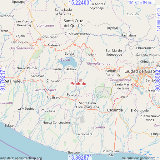
Pochuta GPS coordinates[2]
14° 32' 40.2" North, 91° 5' 20.544" West
| Map corner | latitude | longitude |
|---|---|---|
| Upper-left | 15.22403°, | -91.79217° |
| Center: | 14.5445°, | -91.08904° |
| Lower-right: | 13.86287°, | -90.38592° |
| Map W x H: | 151.3×151.3 km | = 94×94mi |
| max Lat: | 17.06606° ⇑77.3% North |
| Pochuta: | 14.5445° |
| min Lat: | ⇓22.7% South 13.9274° |
| min Long | Pochuta | max Long |
| -92.19298° | -91.08904° | -88.59444° |
| W 45.7%⇐ | ⇒54.3% E |
Elevation
Elevation of Pochuta is 953 m = 3127 ft, and this is 314 m = 1030 ft below average elevation for this country.
| Max E: |
3254 m = 10676 ft | 60.2% |
| Avg. | 1267 m = 4157 ft | |
| Pochuta | 953 m = 3127 ft | |
Min E: |
1 m = 3 ft | 39.8% |
See also: Guatemala elevation on elevation.city.
Geographical zone
Pochuta is located in North Torrid zone (between Equator and Tropic of Cancer). Distance of this Northern Tropic circle is 988.7 km =614.3 mi to North.| Distance of | km | miles | from Pochuta |
|---|---|---|---|
| North Pole | 8389.9 | 5213.2 | to North |
| Arctic Circle | 5784 | 3594 | to North |
| Tropic Cancer | 988.7 | 614.3 | to North |
| Equator | 1617.2 | 1004.9 | to South |


Nearby cities:
15 places around Pochuta: (largest is in red/bold)
• Acatenango
15.7 km =9.8 mi,  85°
85°
• Panajachel
23.1 km =14.4 mi,  341°
341°
• Patulul
15.5 km =9.6 mi,  209°
209°
• Patzicía
20 km =12.4 mi,  60°
60°
• Patzún
17.3 km =10.7 mi,  27°
27°
• San Andrés Semetabaj
22.8 km =14.2 mi,  347°
347°
• San Antonio Palopó
16.7 km =10.4 mi, 349°
• San Juan Bautista
16.6 km =10.3 mi,  215°
215°
• San Lucas Tolimán
8.3 km =5.2 mi,  312°
312°
• Santa Bárbara
19.1 km =11.9 mi,  230°
230°
• Santa Catarina Palopó
20.5 km =12.7 mi, 346°
• Santa Cruz Balanyá
24.1 km =15 mi,  49°
49°
• Santa Lucía Cotzumalguapa
24.3 km =15.1 mi,  163°
163°
• Santiago Atitlán
18.3 km =11.4 mi,  304°
304°
• Yepocapa
15.3 km =9.5 mi,  108°
108°
Sources, notices
• [Note1] Compared only with cities in Guatemala existing in our database
• [Src1] Map data: © OpenStreetMap contributors (CC-BY-SA)
• [Src2] Other city data from geonames.org with taken over terms of usage.
• [Src3] Geographical zone / Annual Mean Temperature by Robert A. Rohde @ Wikipedia
