Santa Lucía Cotzumalguapa geodata
Santa Lucía Cotzumalguapa (Escuintla) is a seat of a second-order administrative division; located in Guatemala in America/Guatemala (GMT-6) time zone. With population of 62,097 people, there are 15 cities with bigger population in this country. Compared to other cities in Guatemala, 89.7% of cities are located further ↑North; 51.9% of cities are located further →East and 77.9% of cities have higher elevation than Santa Lucía Cotzumalguapa. Note1
Current local time in Santa Lucía Cotzumalguapa:
03:50 PM, SundayDifference from your time zone: hours


Santa Lucía Cotzumalguapa GPS coordinates[2]
14° 20' 6.18" North, 91° 1' 24.204" West
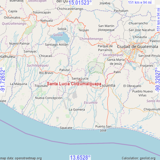
| Map corner | latitude | longitude |
|---|---|---|
| Upper-left | 15.01523°, | -91.72652° |
| Center: | 14.33505°, | -91.02339° |
| Lower-right: | 13.6528°, | -90.32027° |
| Map W x H: | 151.5×151.5 km | = 94.1×94.1mi |
| max Lat: | 17.06606° ⇑89.7% North |
| Santa Lucía Cotzumalguapa: | 14.33505° |
| min Lat: | ⇓10.3% South 13.9274° |
| min Long | Santa Lucía Co | max Long |
| -92.19298° | -91.02339° | -88.59444° |
| W 48.1%⇐ | ⇒51.9% E |
Elevation
Elevation of Santa Lucía Cotzumalguapa is 392 m = 1286 ft, and this is 875 m = 2871 ft below average elevation for this country.
| Max E: |
3254 m = 10676 ft | 77.9% |
| Avg. | 1267 m = 4157 ft | |
| Santa Lucía Cotzumalguapa | 392 m = 1286 ft | |
Min E: |
1 m = 3 ft | 22.1% |
See also: Santa Lucía Cotzumalguapa elevation on elevation.city.
Geographical zone
Santa Lucía Cotzumalguapa is located in North Torrid zone (between Equator and Tropic of Cancer). Distance of this Northern Tropic circle is 1012 km =628.8 mi to North.| Distance of | km | miles | from Santa Lucía Cotzumalguapa |
|---|---|---|---|
| North Pole | 8413.2 | 5227.7 | to North |
| Arctic Circle | 5807.3 | 3608.5 | to North |
| Tropic Cancer | 1012 | 628.8 | to North |
| Equator | 1593.9 | 990.4 | to South |


Nearby cities:
15 places around Santa Lucía Cotzumalguapa: (largest is in red/bold)
• Acatenango
25.9 km =16.1 mi,  19°
19°
• Alotenango
28.3 km =17.6 mi,  55°
55°
• Escuintla
25.9 km =16.1 mi,  97°
97°
• La Democracia
14.2 km =8.8 mi,  144°
144°
• La Gomera
28.3 km =17.6 mi,  186°
186°
• Masagua
23.9 km =14.9 mi,  127°
127°
• Patulul
17.7 km =11 mi,  303°
303°
• Pochuta
24.3 km =15.1 mi,  343°
343°
• Río Bravo
32.5 km =20.2 mi,  282°
282°
• San Juan Bautista
19.4 km =12.1 mi, 300°
• San Lucas Tolimán
31.8 km =19.8 mi, 335°
• San Miguel Dueñas
31.9 km =19.8 mi,  49°
49°
• Santa Bárbara
24.6 km =15.3 mi, 297°
• Siquinalá
7.1 km =4.4 mi,  117°
117°
• Yepocapa
20 km =12.4 mi, 21°
Sources, notices
• [Note1] Compared only with cities in Guatemala existing in our database
• [Src1] Map data: © OpenStreetMap contributors (CC-BY-SA)
• [Src2] Other city data from geonames.org with taken over terms of usage.
• [Src3] Geographical zone / Annual Mean Temperature by Robert A. Rohde @ Wikipedia
