Santa Rosa de Lima geodata
Santa Rosa de Lima (Santa Rosa) is a seat of a second-order administrative division; located in Guatemala in America/Guatemala (GMT-6) time zone. With population of 5,984 people, there are 190 cities with bigger population in this country. Compared to other cities in Guatemala, 88.8% of cities are located further ↑North; 72.9% of cities are located further ←West and 60.5% of cities have higher elevation than Santa Rosa de Lima. Note1


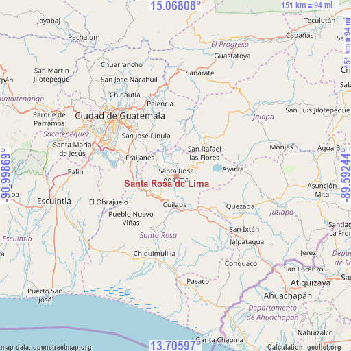
Santa Rosa de Lima GPS coordinates[2]
14° 23' 17.016" North, 90° 17' 44.016" West
| Map corner | latitude | longitude |
|---|---|---|
| Upper-left | 15.06808°, | -90.99869° |
| Center: | 14.38806°, | -90.29556° |
| Lower-right: | 13.70597°, | -89.59244° |
| Map W x H: | 151.5×151.5 km | = 94.1×94.1mi |
| max Lat: | 17.06606° ⇑88.8% North |
| Santa Rosa de Lima: | 14.38806° |
| min Lat: | ⇓11.2% South 13.9274° |
| min Long | Santa Rosa de L | max Long |
| -92.19298° | -90.29556° | -88.59444° |
| W 72.9%⇐ | ⇒27.1% E |
Elevation
Elevation of Santa Rosa de Lima is 948 m = 3110 ft, and this is 319 m = 1047 ft below average elevation for this country.
| Max E: |
3254 m = 10676 ft | 60.5% |
| Avg. | 1267 m = 4157 ft | |
| Santa Rosa de Lima | 948 m = 3110 ft | |
Min E: |
1 m = 3 ft | 39.5% |
See also: Guatemala elevation on elevation.city.
Geographical zone
Santa Rosa de Lima is located in North Torrid zone (between Equator and Tropic of Cancer). Distance of this Northern Tropic circle is 1006.1 km =625.2 mi to North.| Distance of | km | miles | from Santa Rosa de Lima |
|---|---|---|---|
| North Pole | 8407.3 | 5224.1 | to North |
| Arctic Circle | 5801.4 | 3604.8 | to North |
| Tropic Cancer | 1006.1 | 625.2 | to North |
| Equator | 1599.8 | 994.1 | to South |


Nearby cities:
15 places around Santa Rosa de Lima: (largest is in red/bold)
• Barberena
11.4 km =7.1 mi,  218°
218°
• Casillas
6.6 km =4.1 mi,  58°
58°
• Cuilapa
12.4 km =7.7 mi,  181°
181°
• Fraijanes
17.8 km =11.1 mi,  298°
298°
• Mataquescuintla
19.7 km =12.2 mi,  37°
37°
• Nueva Santa Rosa
2.2 km =1.4 mi,  110°
110°
• Oratorio
22 km =13.7 mi,  144°
144°
• Pueblo Nuevo Viñas
26.5 km =16.5 mi,  227°
227°
• San Carlos Alzatate
28.1 km =17.5 mi, 64°
• San José Acatempa
22.7 km =14.1 mi,  126°
126°
• San José Pinula
21.6 km =13.4 mi,  324°
324°
• San Rafael Las Flores
16 km =9.9 mi,  52°
52°
• Santa Cruz Naranjo
8 km =5 mi,  270°
270°
• Santa María Ixhuatán
22.1 km =13.7 mi,  174°
174°
• Villa Canales
27.8 km =17.3 mi,  292°
292°
Sources, notices
• [Note1] Compared only with cities in Guatemala existing in our database
• [Src1] Map data: © OpenStreetMap contributors (CC-BY-SA)
• [Src2] Other city data from geonames.org with taken over terms of usage.
• [Src3] Geographical zone / Annual Mean Temperature by Robert A. Rohde @ Wikipedia
