San Carlos Alzatate geodata
San Carlos Alzatate (Jalapa) is a seat of a second-order administrative division; located in Guatemala in America/Guatemala (GMT-6) time zone. In our database, there are 325 cities with bigger population. Compared to other cities in Guatemala, 83.2% of cities are located further ↑North; 79.9% of cities are located further ←West and 68.4% of cities have lower elevation than San Carlos Alzatate. Note1


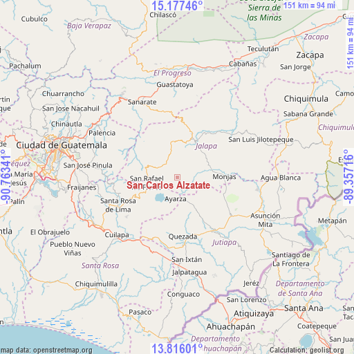
San Carlos Alzatate GPS coordinates[2]
14° 29' 52.008" North, 90° 3' 37.008" West
| Map corner | latitude | longitude |
|---|---|---|
| Upper-left | 15.17746°, | -90.76341° |
| Center: | 14.49778°, | -90.06028° |
| Lower-right: | 13.81601°, | -89.35716° |
| Map W x H: | 151.4×151.4 km | = 94.1×94.1mi |
| max Lat: | 17.06606° ⇑83.2% North |
| San Carlos Alzatate: | 14.49778° |
| min Lat: | ⇓16.8% South 13.9274° |
| min Long | San Carlos Alza | max Long |
| -92.19298° | -90.06028° | -88.59444° |
| W 79.9%⇐ | ⇒20.1% E |
Elevation
Elevation of San Carlos Alzatate is 1767 m = 5797 ft, and this is 500 m = 1640 ft above average elevation for this country.
| Max E: |
3254 m = 10676 ft | 31.6% |
| San Carlos Alzatate | 1767 m 5797 ft | |
| Avg. | 1267 m = 4157 ft | |
Min E: |
1 m = 3 ft | 68.4% |
See also: Guatemala elevation on elevation.city.
Geographical zone
San Carlos Alzatate is located in North Torrid zone (between Equator and Tropic of Cancer). Distance of this Northern Tropic circle is 993.9 km =617.6 mi to North.| Distance of | km | miles | from San Carlos Alzatate |
|---|---|---|---|
| North Pole | 8395.1 | 5216.5 | to North |
| Arctic Circle | 5789.2 | 3597.2 | to North |
| Tropic Cancer | 993.9 | 617.6 | to North |
| Equator | 1612 | 1001.7 | to South |


Nearby cities:
15 places around San Carlos Alzatate: (largest is in red/bold)
• Casillas
21.6 km =13.4 mi,  246°
246°
• El Progreso
28 km =17.4 mi,  125°
125°
• Jalapa
17.1 km =10.6 mi,  26°
26°
• Jutiapa
29 km =18 mi,  142°
142°
• Mataquescuintla
13.8 km =8.6 mi,  284°
284°
• Monjas
20.8 km =12.9 mi,  89°
89°
• Nueva Santa Rosa
26.6 km =16.5 mi,  240°
240°
• Oratorio
32.5 km =20.2 mi,  202°
202°
• Quesada
25.4 km =15.8 mi,  175°
175°
• San José Acatempa
26.8 km =16.7 mi, 195°
• San Manuel Chaparrón
31.7 km =19.7 mi, 86°
• San Pedro Pinula
29.4 km =18.3 mi,  50°
50°
• San Rafael Las Flores
13 km =8.1 mi,  259°
259°
• Sansare
28.2 km =17.5 mi,  347°
347°
• Santa Rosa de Lima
28.1 km =17.5 mi, 244°
Sources, notices
• [Note1] Compared only with cities in Guatemala existing in our database
• [Src1] Map data: © OpenStreetMap contributors (CC-BY-SA)
• [Src2] Other city data from geonames.org with taken over terms of usage.
• [Src3] Geographical zone / Annual Mean Temperature by Robert A. Rohde @ Wikipedia
