Nueva Santa Rosa geodata
Nueva Santa Rosa (Santa Rosa) is a seat of a second-order administrative division; located in Guatemala in America/Guatemala (GMT-6) time zone. With population of 10,130 people, there are 126 cities with bigger population in this country. Compared to other cities in Guatemala, 89.1% of cities are located further ↑North; 73.7% of cities are located further ←West and 57.5% of cities have higher elevation than Nueva Santa Rosa. Note1


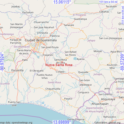
Nueva Santa Rosa GPS coordinates[2]
14° 22' 51.996" North, 90° 16' 33.996" West
| Map corner | latitude | longitude |
|---|---|---|
| Upper-left | 15.06115°, | -90.97924° |
| Center: | 14.38111°, | -90.27611° |
| Lower-right: | 13.69899°, | -89.57299° |
| Map W x H: | 151.5×151.5 km | = 94.1×94.1mi |
| max Lat: | 17.06606° ⇑89.1% North |
| Nueva Santa Rosa: | 14.38111° |
| min Lat: | ⇓10.9% South 13.9274° |
| min Long | Nueva Santa Ros | max Long |
| -92.19298° | -90.27611° | -88.59444° |
| W 73.7%⇐ | ⇒26.3% E |
Elevation
Elevation of Nueva Santa Rosa is 1001 m = 3284 ft, and this is 266 m = 873 ft below average elevation for this country.
| Max E: |
3254 m = 10676 ft | 57.5% |
| Avg. | 1267 m = 4157 ft | |
| Nueva Santa Rosa | 1001 m = 3284 ft | |
Min E: |
1 m = 3 ft | 42.5% |
See also: Guatemala elevation on elevation.city.
Geographical zone
Nueva Santa Rosa is located in North Torrid zone (between Equator and Tropic of Cancer). Distance of this Northern Tropic circle is 1006.9 km =625.7 mi to North.| Distance of | km | miles | from Nueva Santa Rosa |
|---|---|---|---|
| North Pole | 8408 | 5224.5 | to North |
| Arctic Circle | 5802.1 | 3605.3 | to North |
| Tropic Cancer | 1006.9 | 625.7 | to North |
| Equator | 1599 | 993.6 | to South |


Nearby cities:
15 places around Nueva Santa Rosa: (largest is in red/bold)
• Barberena
12.3 km =7.6 mi,  228°
228°
• Casillas
5.5 km =3.4 mi,  39°
39°
• Cuilapa
11.9 km =7.4 mi,  191°
191°
• Fraijanes
20.1 km =12.5 mi,  297°
297°
• Mataquescuintla
19.2 km =11.9 mi,  31°
31°
• Oratorio
20.2 km =12.6 mi,  147°
147°
• Pueblo Nuevo Viñas
27.6 km =17.1 mi, 231°
• Quesada
28.2 km =17.5 mi,  115°
115°
• San Carlos Alzatate
26.6 km =16.5 mi,  60°
60°
• San José Acatempa
20.6 km =12.8 mi,  128°
128°
• San José Pinula
23.5 km =14.6 mi,  321°
321°
• San Rafael Las Flores
14.9 km =9.3 mi, 44°
• Santa Cruz Naranjo
10.1 km =6.3 mi,  274°
274°
• Santa María Ixhuatán
21.2 km =13.2 mi,  179°
179°
• Santa Rosa de Lima
2.2 km =1.4 mi,  290°
290°
Sources, notices
• [Note1] Compared only with cities in Guatemala existing in our database
• [Src1] Map data: © OpenStreetMap contributors (CC-BY-SA)
• [Src2] Other city data from geonames.org with taken over terms of usage.
• [Src3] Geographical zone / Annual Mean Temperature by Robert A. Rohde @ Wikipedia
